 geodata-info
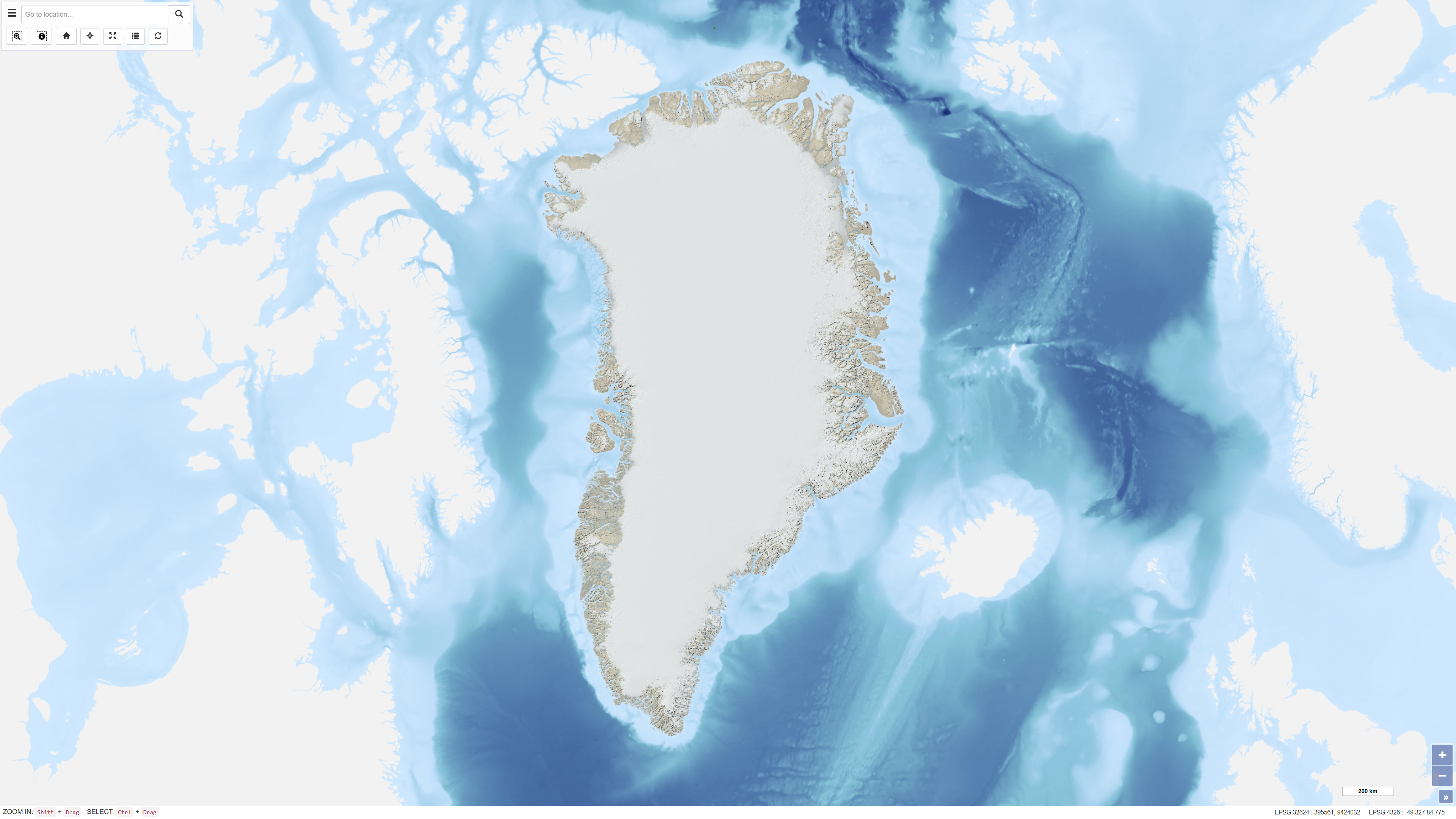
Multidirektionel hillshade afledt af GIMP Digital Elevation Model, Grønland
Multidirectional hillshade derived from the GIMP Digital Elevation Model, Greenland
Datasættet omfatter en multidirektionel hillshade-raster afledt af Greenland Mapping Project (GIMP) Digital Elevation Model. Hillshade-produktet er fremstillet med henblik på anvendelse som et semitransparent overlay i kartografiske produkter, hvor terrænets dybde og detaljer fremhæves, samtidig med at de oprindelige farver i underliggende kortlag bevares.
Den multidirektionelle belysningsmetode synliggør terrænvariation fra flere lysretninger og giver en forbedret repræsentation af landskabsformer sammenlignet med traditionel hillshade med én lyskilde. Datasættet er beregnet til visualiseringsformål i webkort og andre kortprodukter.
This dataset comprises a multidirectional hillshade raster derived from the Greenland Mapping Project (GIMP) Digital Elevation Model. The hillshade was produced to serve as a semi-transparent overlay for cartographic applications, enhancing terrain depth and surface detail while preserving the original colour characteristics of underlying map layers.
The multidirectional illumination method reveals terrain variation from multiple light directions, providing improved representation of landforms compared to traditional single-direction hillshading. The dataset is intended for visualisation purposes in web maps and other cartographic products.
Simple
Identifikation
- Titel
-
Multidirektionel hillshade afledt af GIMP Digital Elevation Model, Grønland
Multidirectional hillshade derived from the GIMP Digital Elevation Model, Greenland
Offentliggørelsestidspunkt
-
Dato (Publication)Dato (Publication)
- 2023-03-24
Ansvarlig myndighed og kontaktoplysninger
- Kontakt vedr. service
-
Organisationsnavn E-mail adresse Rolle De Nationale Geologiske Undersøgelser for Danmark og Grønland (GEUS)
The Geological Survey of Denmark and Greenland (GEUS)
Point of contactPoint of contact
- Metadata author
-
Organisationsnavn E-mail adresse Rolle De Nationale Geologiske Undersøgelser for Danmark og Grønland (GEUS)
The Geological Survey of Denmark and Greenland (GEUS)
Point of contactPoint of contact
Geografisk udstrækning
- Koordinatsystem
-
WGS 84 / UTM 24N (EPSG:32624)
WGS 84 / UTM 24N (EPSG:32624)
Nøgleord
-
NøgleordNøgleord
-
Datasæt
Dataset
-
NøgleordNøgleord
-
Skyggelægning
Hillshade
-
NøgleordNøgleord
-
Digital højdemodel
Digital elevation model
-
NøgleordNøgleord
-
Grønland
Greenland
-
NøgleordNøgleord
-
GIMP
GIMP
-
TypeType
-
ThemeTheme
-
NøgleordNøgleord
-
Geovidenskab og historiepolitikGeoscience and history policy
-
TypeType
-
ThemeTheme
-
Titel
-
Forskningsemner
-
Dato (Publication)Dato (Publication)
- 2025-11-03
-
NøgleordNøgleord
-
GrønlandGreenland
-
TypeType
-
PlacePlace
-
Titel
-
Geografisk
-
Dato (Publication)Dato (Publication)
- 2025-12-11
Kvalitet
-
Type som metadata beskriverType som metadata beskriver
-
DatasetDataset
-
BeskrivelseBeskrivelse
-
Den multidirektionelle hillshade er afledt af Greenland Mapping Project (GIMP) Digital Elevation Model (Howat et al., 2014). GIMP DEM leverer højdedata for Grønland og udgør det topografiske grundlag for dette visualiseringsprodukt.
Hillshade er genereret ved anvendelse af en multidirektionel belysningsteknik inspireret af Eduard Imhofs kartografiske principper. Der er anvendt justeret skalering egnet til store kortudstrækninger for at fremhæve terrænvariation på flere skalaniveauer. En farverampe med graduelle transparenseffekter er kombineret med billedbehandling for at bevare både terrændetaljer og underliggende kortfarver, hvilket resulterer i et semitransparent kartografisk overlay.
The multidirectional hillshade was derived from the Greenland Mapping Project (GIMP) Digital Elevation Model (Howat et al., 2014). The GIMP DEM provides surface elevation data for Greenland and forms the topographic basis for this visualisation product.
The hillshade was generated using a multidirectional illumination technique inspired by the cartographic principles of Eduard Imhof. Adjusted scaling suitable for large map extents was applied to enhance terrain variation across multiple scales. A colour ramp with intermediate transparency levels was combined with image processing techniques to preserve both terrain detail and underlying map colours, producing a semi-transparent cartographic overlay.
)))
