 geodata-info
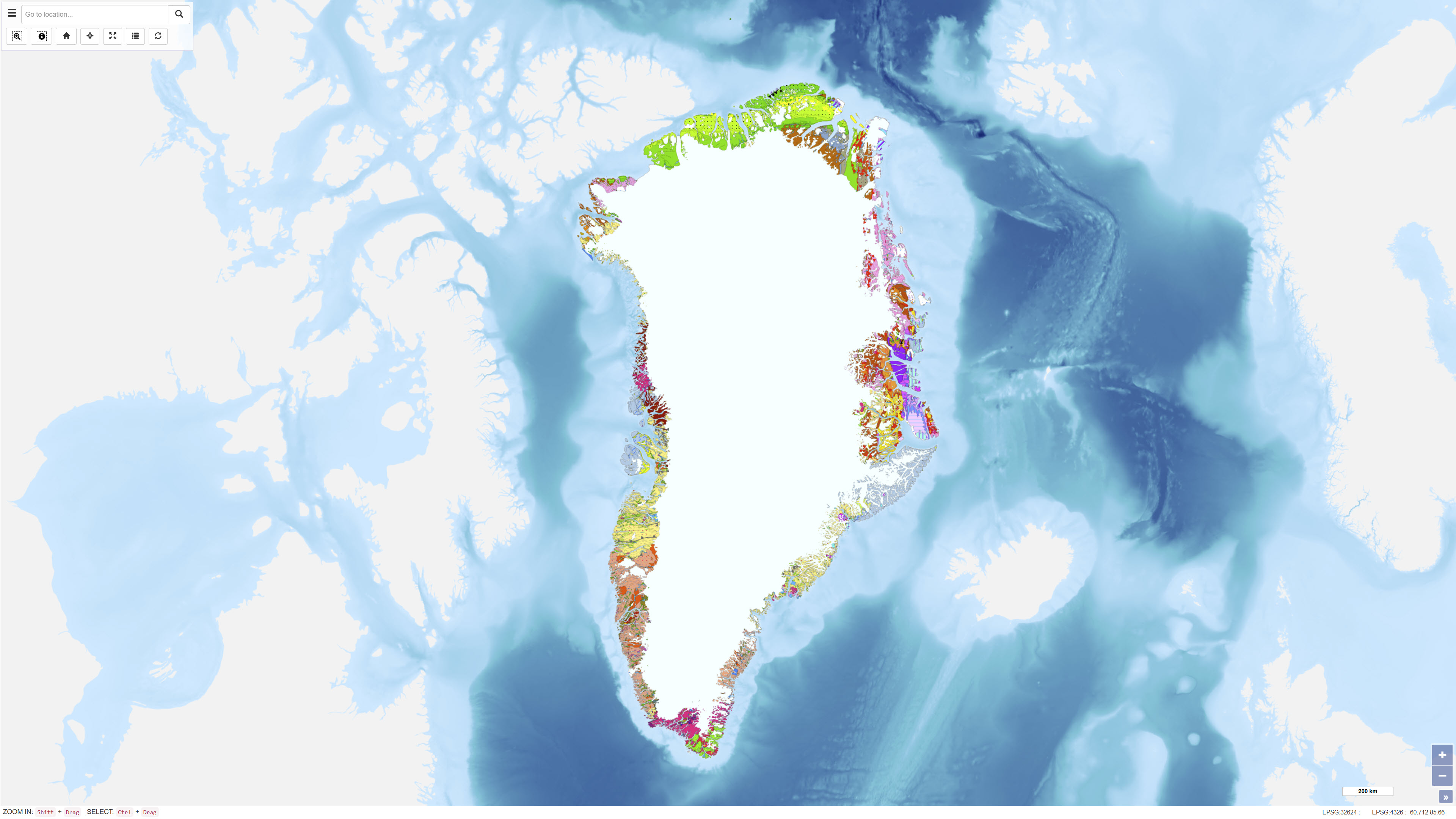
Geological map of Greenland, 1:2.500.000
The Geological Map of Greenland at scale 1:2.500.000 provides a comprehensive regional synthesis of the geological evolution of Greenland from the earliest Archaean to the Quaternary. The map presents an integrated overview of Greenland’s geological framework, including Precambrian crystalline basement provinces, major orogenic belts, Phanerozoic sedimentary basins and widespread volcanic provinces.
Greenland is characterised by large exposures of continental crust dominated by Archaean and early Proterozoic shield rocks that stabilised as part of the Laurentian shield. Younger geological elements are mainly developed along the margins of the shield, where sedimentation, deformation and magmatic activity reflect successive tectonic regimes through time. The map illustrates the distribution and relationships of these geological units and highlights the structural and stratigraphic architecture of Greenland and adjacent offshore areas.
The map integrates onshore and offshore geological information and serves as a regional reference for geological interpretation, research, education and resource-related studies in Greenland.
Simple
Identifikation
- Titel
-
Geological map of Greenland, 1:2.500.000
Offentliggørelsestidspunkt
- Dato (Publication)
- 2000-12-29
Ansvarlig myndighed og kontaktoplysninger
- Kontakt vedr. service
-
Organisationsnavn E-mail adresse Rolle The Geological Survey of Denmark and Greenland (GEUS)
Author The Geological Survey of Denmark and Greenland (GEUS)
Point of contact The Geological Survey of Denmark and Greenland (GEUS)
Distributor
- Metadata author
-
Organisationsnavn E-mail adresse Rolle The Geological Survey of Denmark and Greenland (GEUS)
Point of contact
Geografisk udstrækning
- Koordinatsystem
-
WGS 84 / UTM 24N (EPSG:32624)
Nøgleord
- Nøgleord
-
Dataset
- Nøgleord
-
Geology
- Nøgleord
-
Greenland
- Nøgleord
-
Stratigraphy
- Nøgleord
-
Structural geology
- Type
- Theme
- Nøgleord
- Tectonics and structural geology
- Nøgleord
- Stratigraphy and correlation
- Type
- Theme
- Titel
- Forskningsemner
- Dato (Publication)
- 2025-11-03
- Nøgleord
- Greenland
- Type
- Place
- Titel
- Geografisk
- Dato (Publication)
- 2025-12-11
Kvalitet
- Type som metadata beskriver
- Dataset
- Beskrivelse
-
The map was produced as a synthesis of geological data and interpretations acquired over several decades and is based on field mapping, geological surveys, borehole data, geophysical investigations and offshore studies. The dataset integrates both onshore and offshore geological information and reflects the geological understanding available at the time of publication. The map represents a regional geological interpretation at a scale of 1:2.500.000.
)))
