 geodata-info
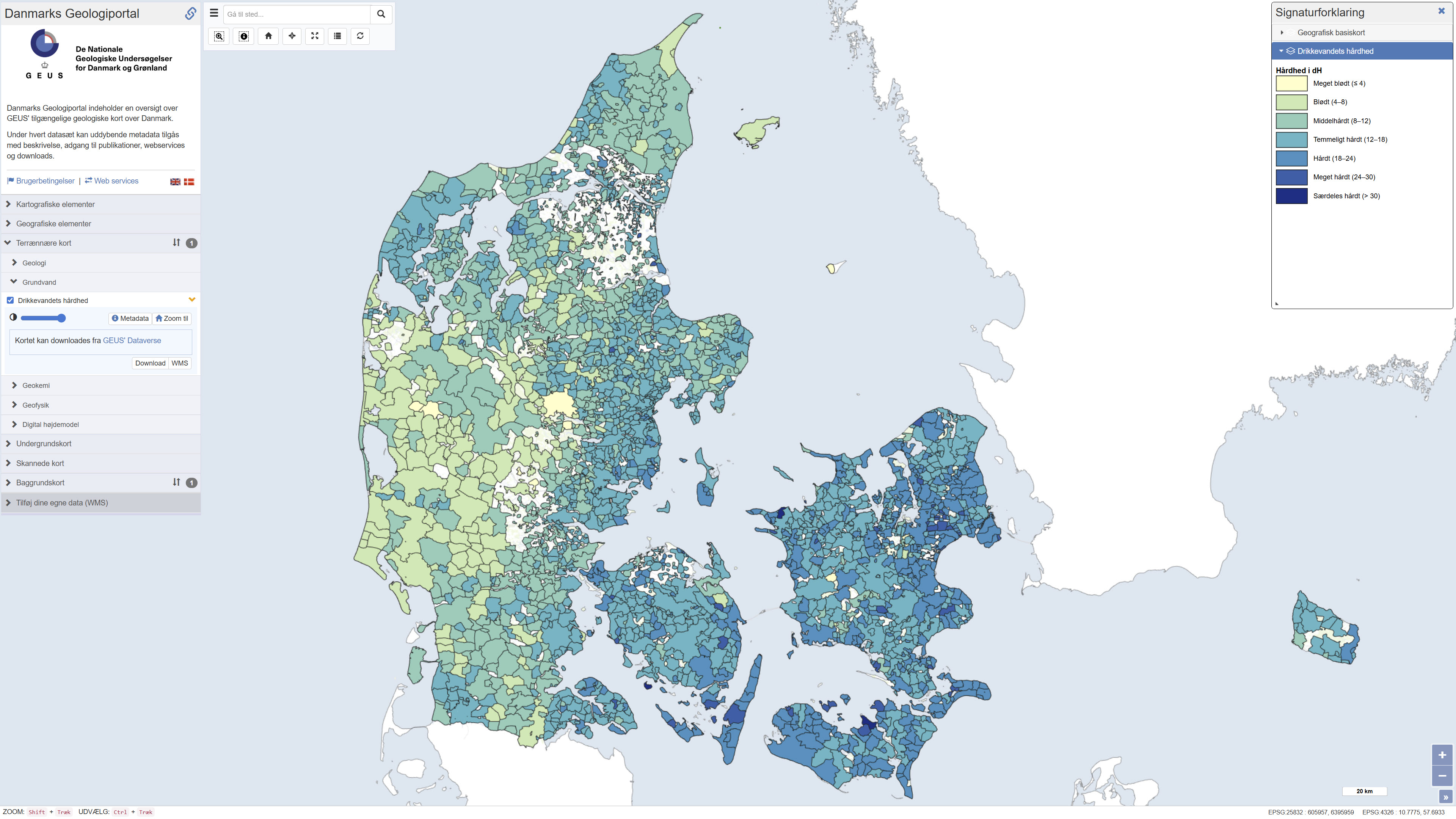
Hardness of Danish drinking water
Map showing information about drinking water hardness (dH) at the level of water supply areas of public waterworks in Denmark based on quality-assured data, extracted from the national well-database Jupiter in September 2023. The hardness degree is based on the concentration of calcium and magnesium in the drinking water and has importance, for example, for the soap dosage when washing clothes: hard water requires more soap than soft water. Drinking water hardness may vary considerably from location to location and in time. Contact your water utility company to get the updated and precise figures.
Simple
Identifikation
- Titel
-
Hardness of Danish drinking water
Offentliggørelsestidspunkt
- Dato (Publication)
- 2024-09-05
Ansvarlig myndighed og kontaktoplysninger
- Kontakt vedr. service
-
Organisationsnavn E-mail adresse Rolle The Geological Survey of Denmark and Greenland (GEUS)
Point of contact The Geological Survey of Denmark and Greenland (GEUS)
Custodian
- Metadata author
-
Organisationsnavn E-mail adresse Rolle The Geological Survey of Denmark and Greenland (GEUS)
Point of contact
Geografisk udstrækning
- Koordinatsystem
-
ETRS 89 / UTM 32N (EPSG:25832)
Nøgleord
- Nøgleord
-
Dataset
- Nøgleord
-
Geology
- Nøgleord
-
Drinking water
- Nøgleord
-
ArcGIS
- Nøgleord
-
QGIS
- Type
- Theme
- Nøgleord
- Quaternary geology
- Nøgleord
- Soils and biogeochemistry
- Type
- Theme
- Titel
- Forskningsemner
- Dato (Publication)
- 2025-11-03
- Nøgleord
- Denmark
- Type
- Place
- Titel
- Geografisk
- Dato (Publication)
- 2025-12-11
Kvalitet
- Type som metadata beskriver
- Dataset
- Beskrivelse
-
The map is based on the latest available hardness information at the water supply areas of public waterworks. The public waterworks metadata and drinking water analyses of Ca, Mg and total hardness were extracted from the Jupiter database on 6 September 2023. The water supply areas are from Schullehner (2022, https://doi.org/10.34194/geusb.v49.8319). Data were quality assured, filtered, aggregated and linked together.
)))
