 geodata-info
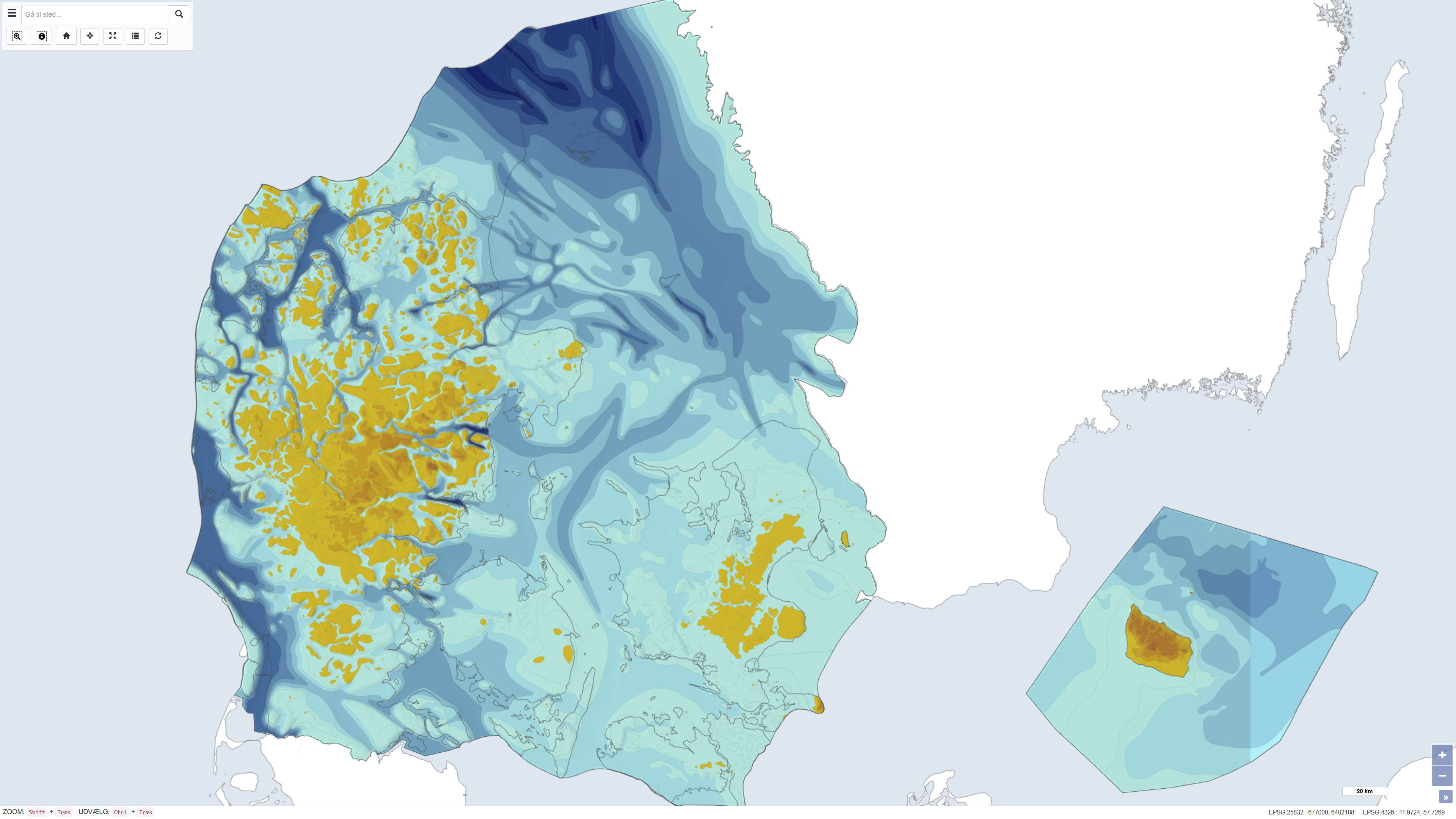
Pre-Quaternary surface topography of Denmark – Geological map of Denmark 1:500.000
This dataset represents the pre-Quaternary surface topography of Denmark, including Kattegat, internal waters and the sea around Bornholm. The map provides a paleotopographic relief of the surface that existed prior to deposition of Quaternary sediments, compiled from geological borehole data, seismic surveys and topographic sources. It includes polygons with 25 m contour intervals, a 500 m grid and boundary delineations, usable in combination with a standard elevation model to determine Quaternary cover thickness. The base map was hand-drawn at 1:250,000 scale and forms a nationwide thematic map product. The map is described in DGU map series no. 44, 1994.
Simple
Identifikation
- Titel
-
Pre-Quaternary surface topography of Denmark – Geological map of Denmark 1:500.000
Offentliggørelsestidspunkt
- Dato (Publication)
- 1993-12-12
Ansvarlig myndighed og kontaktoplysninger
- Kontakt vedr. service
-
Organisationsnavn E-mail adresse Rolle The Geological Survey of Denmark and Greenland (GEUS)
Point of contact
- Metadata author
-
Organisationsnavn E-mail adresse Rolle The Geological Survey of Denmark and Greenland (GEUS)
Point of contact
Geografisk udstrækning
- Koordinatsystem
-
ETRS 89 / UTM 32N (EPSG:25832)
Nøgleord
- Nøgleord
-
Dataset
- Nøgleord
-
Geology
- Nøgleord
-
Pre-Quaternary
- Nøgleord
-
Topography
- Nøgleord
-
Denmark
- Nøgleord
-
Subsurface
- Nøgleord
-
ArcGIS
- Nøgleord
-
QGIS
- Type
- Theme
- Nøgleord
- Quaternary geology
- Nøgleord
- Geoscience and history policy
- Type
- Theme
- Titel
- Forskningsemner
- Dato (Publication)
- 2025-11-03
- Nøgleord
- Denmark
- Type
- Place
- Titel
- Geografisk
- Dato (Publication)
- 2025-12-11
Kvalitet
- Type som metadata beskriver
- Dataset
- Beskrivelse
-
The dataset is documented in DGU Map Series no. 44, published by the Geological Survey of Denmark in 1993/1994 with ISBN 87-89640-98-1 and DOI 10.22008/FK2/TZLEKA/LAEPNZ. The map portrays pre-Quaternary topography based on borehole records from the DGU Bore Archive, seismic surveys, and topographic control. It results from consolidated geological and geophysical data to produce a nationwide paleotopographic map. Further revisions may be incorporated as new borehole and geophysical information becomes available.
)))
