 geodata-info
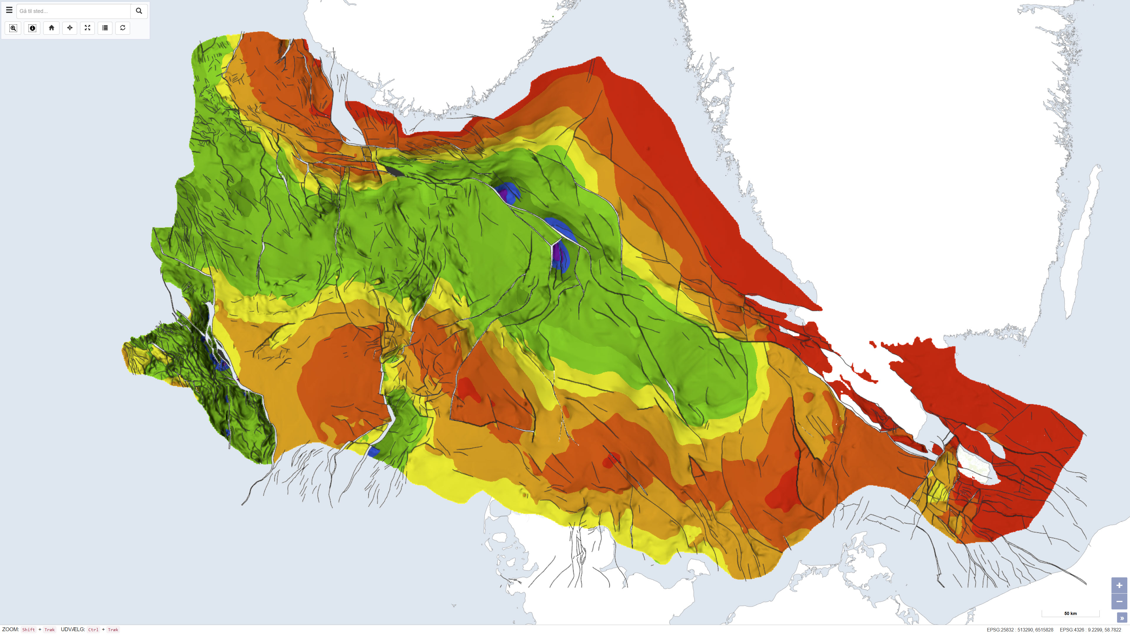
Top præ-Zechstein - Geologiske strukturer i Danmarks undergrund 1:750.000
Top pre-Zechstein - Geological structures in the Danish subsurface 1:750.000
Dette datasæt viser dybden til toppen af præ-Zechstein-aflejringerne i Danmarks undergrund. Kortet repræsenterer den strukturelle overflade under Zechstein-evaporitterne og giver et regionalt overblik over undergrundens geologiske opbygning. Datasættet er baseret på fortolkning af seismiske data, dybe boringer og tidligere geologiske kortlægninger og er udarbejdet som en del af Danmarks Geologiske Undersøgelses kortserie nr. 45. Kortet anvendes som reference for regional strukturel geologi og undergrundsmodeller.
This dataset depicts the depth to the top of the pre-Zechstein succession in the Danish subsurface. The map represents the structural surface beneath the Zechstein evaporites and provides a regional overview of the geological framework of the subsurface. The dataset is based on interpretation of seismic data, deep boreholes and previous geological mapping and was produced as part of the Geological Survey of Denmark map series no. 45. The map is used as a reference for regional structural geology and subsurface modelling.
Simple
Identifikation
- Titel
-
Top præ-Zechstein - Geologiske strukturer i Danmarks undergrund 1:750.000
Top pre-Zechstein - Geological structures in the Danish subsurface 1:750.000
Offentliggørelsestidspunkt
-
Dato (Publication)Dato (Publication)
- 1994-12-01
Ansvarlig myndighed og kontaktoplysninger
- Kontakt vedr. service
-
Organisationsnavn E-mail adresse Rolle De Nationale Geologiske Undersøgelser for Danmark og Grønland (GEUS)
The Geological Survey of Denmark and Greenland (GEUS)
Point of contactPoint of contact
- Metadata author
-
Organisationsnavn E-mail adresse Rolle De Nationale Geologiske Undersøgelser for Danmark og Grønland (GEUS)
The Geological Survey of Denmark and Greenland (GEUS)
Point of contactPoint of contact
Geografisk udstrækning
- Koordinatsystem
-
ETRS 89 / UTM 32N (EPSG:25832)
ETRS 89 / UTM 32N (EPSG:25832)
Nøgleord
-
NøgleordNøgleord
-
Datasæt
Dataset
-
NøgleordNøgleord
-
Geologi
Geology
-
NøgleordNøgleord
-
Geologiske strukturer
Geological structures
-
NøgleordNøgleord
-
Præ-Zechstein
Pre-Zechstein
-
NøgleordNøgleord
-
Undergrund
Subsurface
-
NøgleordNøgleord
-
Danmark
Denmark
-
TypeType
-
ThemeTheme
-
NøgleordNøgleord
-
Tektonik og strukturgeologiTectonics and structural geology
-
NøgleordNøgleord
-
Geovidenskab og historiepolitikGeoscience and history policy
-
TypeType
-
ThemeTheme
-
Titel
-
Forskningsemner
-
Dato (Publication)Dato (Publication)
- 2025-11-03
-
NøgleordNøgleord
-
DanmarkDenmark
-
TypeType
-
PlacePlace
-
Titel
-
Geografisk
-
Dato (Publication)Dato (Publication)
- 2025-12-11
Kvalitet
-
Type som metadata beskriverType som metadata beskriver
-
DatasetDataset
-
BeskrivelseBeskrivelse
-
Datasættet er udarbejdet af Danmarks Geologiske Undersøgelse som en del af DGU Kortserie nr. 45 og bygger på sammenstilling og fortolkning af seismiske profiler, dybe boringer og eksisterende geologiske modeller. Kortet repræsenterer fortolkningsniveauet på udgivelsestidspunktet og er produceret i begyndelsen af 1990’erne. Produktionen er gennemført i regi af DGU under Miljø- og Energiministeriet og afspejler den daværende viden om undergrundens strukturelle opbygning.
The dataset was produced by the Geological Survey of Denmark as part of DGU map series no. 45 and is based on compilation and interpretation of seismic profiles, deep boreholes and existing geological models. The map reflects the interpretation level at the time of publication and was produced in the early 1990s. The production was carried out under the auspices of the Geological Survey of Denmark within the Ministry of Environment and Energy and reflects the contemporary understanding of subsurface structural geology.
)))
