 geodata-info
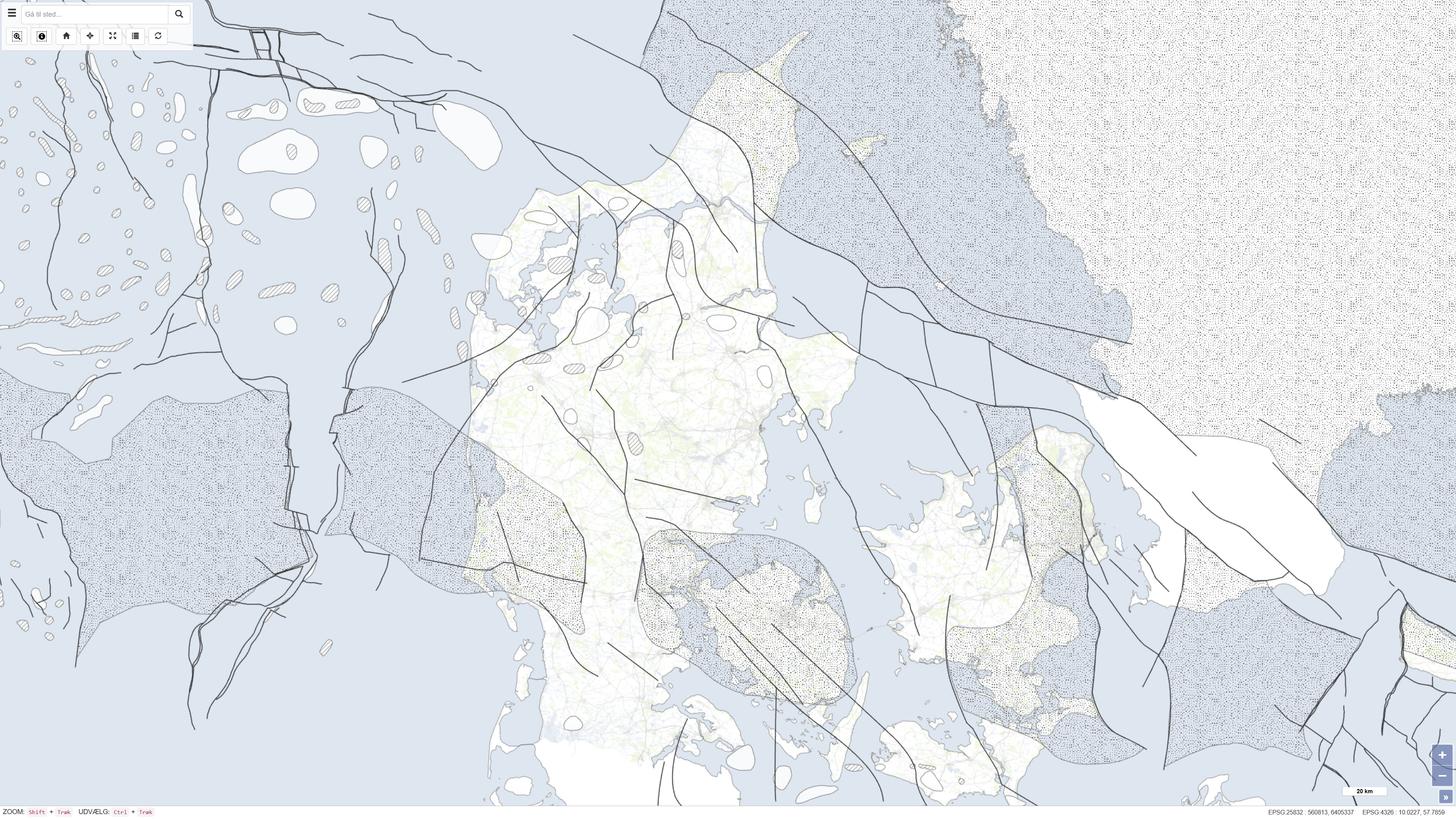
Strukturelle elementer i det danske område
Structural features in the Danish area
Dette datasæt er baseret på Danmarks Geologiske Undersøgelses kortserie nr. 45 og repræsenterer et samlet geologisk kortprodukt udarbejdet i begyndelsen af 1990’erne. Kortet er baseret på eksisterende geologiske kort, seismiske undersøgelser og tidligere tolkninger og giver en regional oversigt over de geologiske forhold inden for det kortlagte område. Datasættet indgår som en del af DGU’s nationale kortlægningsindsats og er publiceret i 1994.
This dataset is based on the Geological Survey of Denmark map series no. 45 and represents a compiled geological map product produced in the early 1990s. The map is based on existing geological maps, seismic surveys, and previous interpretations, providing a regional overview of the geological conditions within the mapped area. The dataset forms part of the national mapping activities of the Geological Survey of Denmark and was published in 1994.
Simple
Identifikation
- Titel
-
Strukturelle elementer i det danske område
Structural features in the Danish area
Offentliggørelsestidspunkt
-
Dato (Publication)Dato (Publication)
- 1994-01-01
Ansvarlig myndighed og kontaktoplysninger
- Kontakt vedr. service
-
Organisationsnavn E-mail adresse Rolle De Nationale Geologiske Undersøgelser for Danmark og Grønland (GEUS)
The Geological Survey of Denmark and Greenland (GEUS)
Point of contactPoint of contact
- Metadata author
-
Organisationsnavn E-mail adresse Rolle De Nationale Geologiske Undersøgelser for Danmark og Grønland (GEUS)
The Geological Survey of Denmark and Greenland (GEUS)
Point of contactPoint of contact
Geografisk udstrækning
- Koordinatsystem
-
ETRS 89 / UTM 32N (EPSG:25832)
ETRS 89 / UTM 32N (EPSG:25832)
Nøgleord
-
NøgleordNøgleord
-
Datasæt
Dataset
-
NøgleordNøgleord
-
Geologi
Geology
-
NøgleordNøgleord
-
Undergrund
Subsurface
-
NøgleordNøgleord
-
Danmark
Denmark
-
NøgleordNøgleord
-
Strukturer
Structures
-
TypeType
-
ThemeTheme
-
NøgleordNøgleord
-
Tektonik og strukturgeologiTectonics and structural geology
-
TypeType
-
ThemeTheme
-
Titel
-
Forskningsemner
-
Dato (Publication)Dato (Publication)
- 2025-11-03
-
NøgleordNøgleord
-
DanmarkDenmark
-
TypeType
-
PlacePlace
-
Titel
-
Geografisk
-
Dato (Publication)Dato (Publication)
- 2025-12-11
Kvalitet
-
Type som metadata beskriverType som metadata beskriver
-
DatasetDataset
-
BeskrivelseBeskrivelse
-
Datasættet er udarbejdet af Danmarks Geologiske Undersøgelse som en del af kortserie nr. 45 og er baseret på sammenstilling og fortolkning af eksisterende geologiske kort, seismiske data og tidligere undersøgelser. Kortet er produceret i begyndelsen af 1990’erne og afspejler datagrundlag og fortolkningsniveau på udgivelsestidspunktet. Produktionen er gennemført i regi af DGU under Miljø- og Energiministeriet.
The dataset was produced by the Geological Survey of Denmark as part of map series no. 45 and is based on compilation and interpretation of existing geological maps, seismic data, and previous investigations. The map was produced in the early 1990s and reflects the data availability and interpretation level at the time of publication. The production was carried out under the auspices of the Geological Survey of Denmark within the Ministry of Environment and Energy.
)))
