 geodata-info
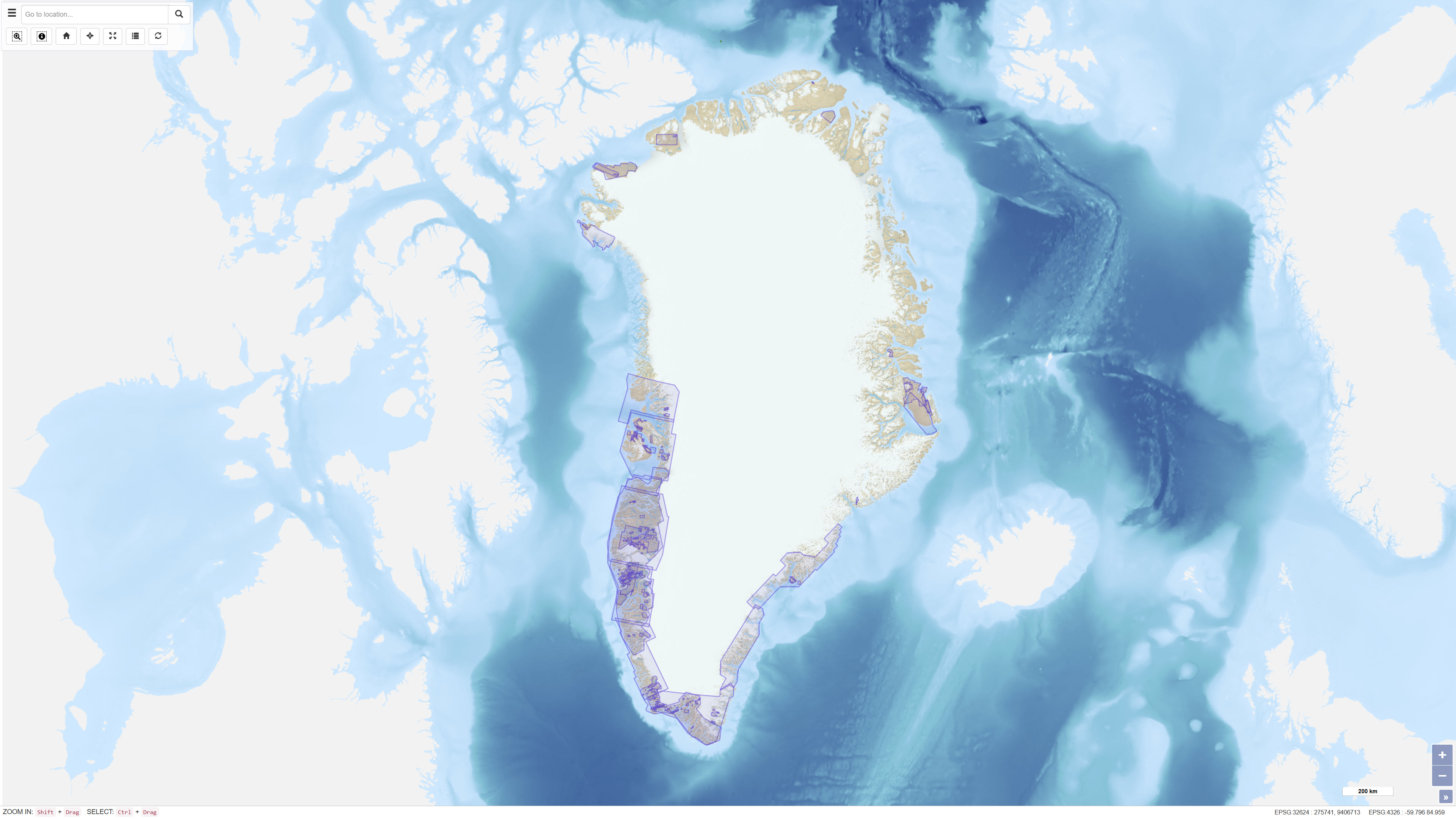
Geofysiske undersøgelsesdata, Grønland
Geophysical survey data, Greenland
Datasættet omfatter geofysiske surveydata tilgængelige via Greenland Mineral Resources Portal. Data omfatter både frigivne selskabsdata og offentligt finansierede surveys, primært luftbårne elektromagnetiske (AEM) og aeromagnetiske undersøgelser.
AEM Greenland 1994–1998-projektet omfattede højtopløselige, multiparametriske luftbårne undersøgelser med elektromagnetiske, magnetiske og delvist radiometriske målinger udført i perioden 1994–1998 og producerede i alt cirka 75.000 linjekilometer data.
Aeromag-projekterne omfattede højtopløselige luftbårne magnetiske målinger udført i 1992, 1995, 1996, 1997, 1998, 1999, 2001, 2012 og 2013 og producerede mere end 550.000 linjekilometer data. Projekterne blev finansieret af Grønlands og Danmarks regeringer.
Datasættet giver regional geofysisk dækning til brug for geologisk fortolkning, mineralefterforskning og geovidenskabelig forskning i Grønland.
The dataset comprises geophysical survey data available through the Greenland Mineral Resources Portal. The data include both released company data and publicly funded survey data, primarily airborne electromagnetic (AEM) and aeromagnetic (Aeromag) surveys.
The AEM Greenland 1994–1998 project encompassed high-resolution, multi-parameter airborne surveys including electromagnetic, magnetic and partly radiometric measurements conducted between 1994 and 1998, producing approximately 75,000 line kilometres of data.
The Aeromag projects included high-resolution airborne magnetic surveys conducted in 1992, 1995, 1996, 1997, 1998, 1999, 2001, 2012 and 2013, producing more than 550,000 line kilometres of data. The projects were financed by the governments of Greenland and Denmark.
The dataset provides regional geophysical coverage supporting geological interpretation, mineral exploration and geoscientific research in Greenland.
Simple
Identifikation
- Titel
-
Geofysiske undersøgelsesdata, Grønland
Geophysical survey data, Greenland
Offentliggørelsestidspunkt
-
Dato (Publication)Dato (Publication)
- 2023-12-04
Ansvarlig myndighed og kontaktoplysninger
- Kontakt vedr. service
-
Organisationsnavn E-mail adresse Rolle De Nationale Geologiske Undersøgelser for Danmark og Grønland (GEUS)
The Geological Survey of Denmark and Greenland (GEUS)
Point of contactPoint of contact
- Metadata author
-
Organisationsnavn E-mail adresse Rolle De Nationale Geologiske Undersøgelser for Danmark og Grønland (GEUS)
The Geological Survey of Denmark and Greenland (GEUS)
Point of contactPoint of contact
Geografisk udstrækning
- Koordinatsystem
-
WGS 84 / UTM 24N (EPSG:32624)
WGS 84 / UTM 24N (EPSG:32624)
Nøgleord
-
NøgleordNøgleord
-
Datasæt
Dataset
-
NøgleordNøgleord
-
Geofysik
Geophysics
-
NøgleordNøgleord
-
Luftbåren geofysik
Airborne geophysics
-
NøgleordNøgleord
-
AEM
AEM
-
NøgleordNøgleord
-
Aeromagnetik
Aeromagnetics
-
NøgleordNøgleord
-
Magnetiske data
Magnetic data
-
NøgleordNøgleord
-
Elektromagnetiske data
Electromagnetic data
-
NøgleordNøgleord
-
Grønland
Greenland
-
NøgleordNøgleord
-
Mineralefterforskning
Mineral exploration
-
TypeType
-
ThemeTheme
-
NøgleordNøgleord
-
Beregningsmæssig geovidenskab, informatik og fjernmålingComputational geoscience, informatics and remote sensing
-
TypeType
-
ThemeTheme
-
Titel
-
Forskningsemner
-
Dato (Publication)Dato (Publication)
- 2025-11-03
-
NøgleordNøgleord
-
GrønlandGreenland
-
TypeType
-
PlacePlace
-
Titel
-
Geografisk
-
Dato (Publication)Dato (Publication)
- 2025-12-11
Kvalitet
-
Type som metadata beskriverType som metadata beskriver
-
DatasetDataset
-
BeskrivelseBeskrivelse
-
Datasættet repræsenterer en kompilation af luftbårne geofysiske undersøgelser udført i Grønland i perioden 1992–2013. Det omfatter både offentligt finansierede surveys (AEM og Aeromag) og frigivne selskabsdata tilgængelige via Greenland Mineral Resources Portal.
AEM-undersøgelserne blev udført i perioden 1994–1998 med multiparametriske luftbårne systemer, der målte elektromagnetiske, magnetiske og radiometriske signaler. Aeromag-undersøgelserne blev gennemført i flere kampagner mellem 1992 og 2013 ved anvendelse af luftbårne magnetometre. Dataindsamlingen blev udført med systematiske linjeafstande og GPS-positionering, hvilket sikrer sammenlignelighed mellem surveys. Detaljeret teknisk dokumentation findes i Geology and Ore No. 22.
The dataset represents a compilation of airborne geophysical surveys conducted in Greenland between 1992 and 2013. It includes publicly funded surveys (AEM and Aeromag) and released company data made available through the Greenland Mineral Resources Portal.
The AEM surveys were conducted between 1994 and 1998 using multi-parameter airborne systems measuring electromagnetic, magnetic and radiometric responses. The Aeromag surveys were conducted in multiple campaigns between 1992 and 2013 using airborne magnetometers. Data acquisition was performed using systematic flight line spacing and GPS positioning, ensuring compatibility between surveys. Detailed technical documentation is provided in Geology and Ore No. 22.
)))
