 geodata-info
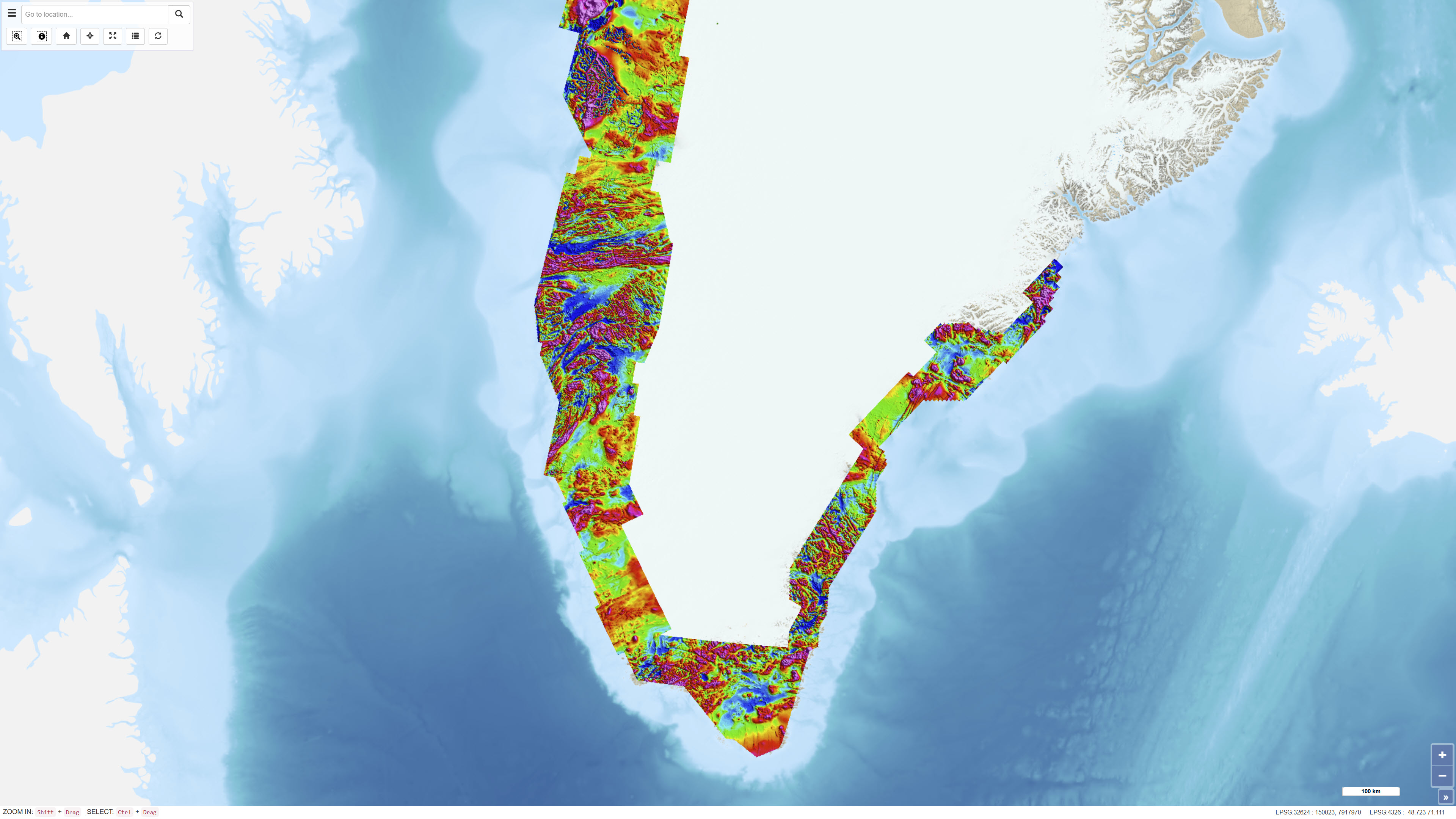
Regional AEROMAG Surveys 1992-2013
The Regional AEROMAG 1992–2013 Surveys comprise a compilation of high-resolution airborne magnetic surveys acquired by GGU/GEUS between 1993 and 2013 and financed by the Government of Greenland. The overlapping surveys cover approximately 300,000 km² and include the total ice-free onshore areas and near-coastal offshore regions of West Greenland, South Greenland and southern East Greenland.
All surveys were acquired using aircraft with similar flight parameters, including line spacings of 500–1,000 m and cross-line spacing of approximately 5,000 m, and with flight altitudes of about 300 m above ground level or seafloor along gently draped surfaces. These consistent acquisition parameters allow the individual surveys to be integrated into a coherent, high-quality regional magnetic data compilation.
The total magnetic anomaly map was generated by merging grids from separately processed datasets using the grid-knitting module in Oasis Montaj. The data are IGRF-corrected but not reduced to the pole, and the crustal magnetic field model MF7 was used as a regional reference grid during compilation.
Simple
Identifikation
- Titel
-
Regional AEROMAG Surveys 1992-2013
Offentliggørelsestidspunkt
- Dato (Publication)
- 2020-02-17
Ansvarlig myndighed og kontaktoplysninger
- Kontakt vedr. service
-
Organisationsnavn E-mail adresse Rolle The Geological Survey of Denmark and Greenland (GEUS)
Point of contact
- Metadata author
-
Organisationsnavn E-mail adresse Rolle The Geological Survey of Denmark and Greenland (GEUS)
Point of contact
Geografisk udstrækning
- Koordinatsystem
-
WGS 84 / UTM 24N (EPSG:32624)
Nøgleord
- Nøgleord
-
Dataset
- Nøgleord
-
Geophysics
- Nøgleord
-
Aeromagnetic
- Nøgleord
-
Airborne geophysics
- Nøgleord
-
Magnetic anomalies
- Nøgleord
-
Greenland
- Nøgleord
-
Mineral exploration
- Type
- Theme
- Nøgleord
- Geoscience and history policy
- Type
- Theme
- Titel
- Forskningsemner
- Dato (Publication)
- 2025-11-03
- Nøgleord
- Denmark
- Type
- Place
- Titel
- Geografisk
- Dato (Publication)
- 2025-12-11
Kvalitet
- Type som metadata beskriver
- Dataset
- Beskrivelse
-
The dataset is based on a series of airborne magnetic surveys acquired between 1993 and 2013 using aircraft-mounted magnetometers. Surveys were flown with comparable line spacing, cross-line spacing and flight altitude to ensure compatibility across datasets. Data acquisition was performed with GPS positioning and modern instrumentation.
Individual survey datasets were processed separately and subsequently merged into a regional compilation. Grid merging was performed using the grid-knitting module in Oasis Montaj, applying the crustal magnetic field model MF7 as a regional reference grid. The resulting magnetic anomaly data are corrected for the International Geomagnetic Reference Field (IGRF) but are not reduced to the pole.
While the overall data quality is high, some of the older datasets acquired in the early to mid-1990s contain residual levelling artefacts. Further reprocessing is recommended for applications involving higher-order magnetic derivatives.
)))
