 geodata-info
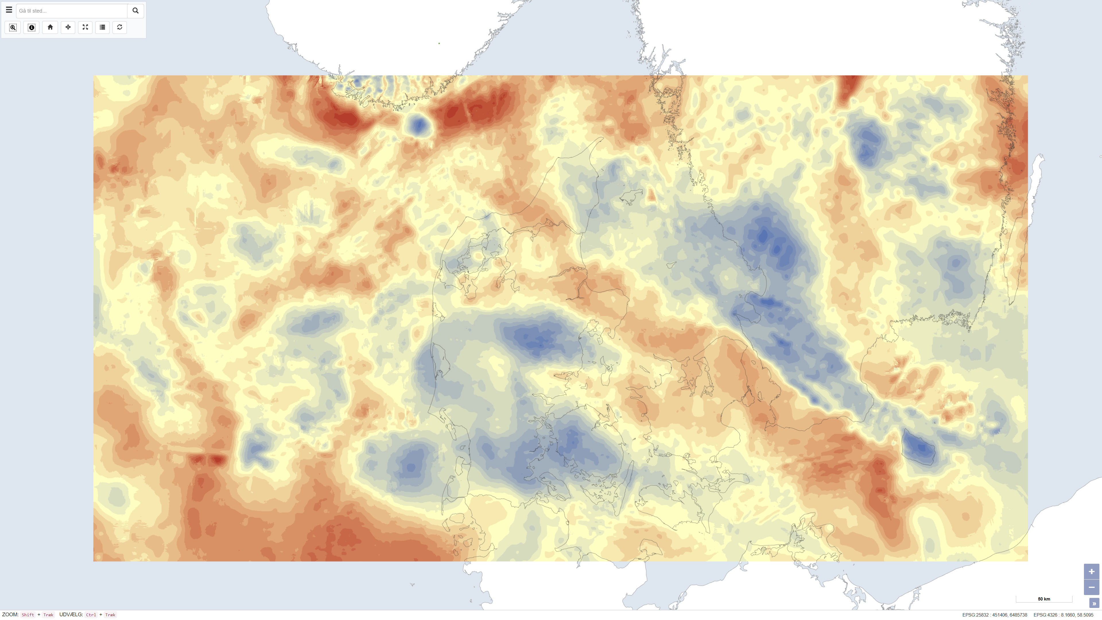
Bouguer- og friluftstyngdekraft over Danmark
Bouguer and free-air gravity anomalies over Denmark
Datasættet viser Bougueranomali på land og friluftstyngdeanomali i de danske havområder baseret på tyngdemålinger fra den nationale tyngdedatabase. Bougueranomali er terrænkorrigeret og anvendes til at belyse variationer i undergrundens massefordeling, mens friluftstyngdeanomalien til søs afspejler variationer i tyngdefeltet uden fuld terrænkorrigering. Tyngdeanomalierne er angivet i milligal (mGal). Datasættet er udarbejdet af DTU Space og repræsenterer et samlet gravimetrisk grundlag for geologiske og geofysiske analyser i Danmark.
The dataset presents Bouguer gravity anomalies on land and free-air gravity anomalies in Danish marine areas based on gravity measurements from the national gravity database. The Bouguer anomaly is terrain corrected and is used to investigate variations in subsurface mass distribution, while the free-air anomaly at sea reflects variations in the gravity field without full terrain correction. Gravity anomalies are expressed in milligals (mGal). The dataset was produced by DTU Space and represents a consolidated gravimetric foundation for geological and geophysical analyses in Denmark.
Simple
Identifikation
- Titel
-
Bouguer- og friluftstyngdekraft over Danmark
Bouguer and free-air gravity anomalies over Denmark
Offentliggørelsestidspunkt
-
Dato (Publication)Dato (Publication)
- 2011-12-12
Ansvarlig myndighed og kontaktoplysninger
- Kontakt vedr. service
-
Organisationsnavn E-mail adresse Rolle The Geological Survey of Denmark and Greenland (GEUS)
De Nationale Geologiske Undersøgelser for Danmark og Grønland (GEUS)
Point of contactPoint of contactDTU Space
DTU Space
AuthorAuthor
- Metadata author
-
Organisationsnavn E-mail adresse Rolle De Nationale Geologiske Undersøgelser for Danmark og Grønland (GEUS)
The Geological Survey of Denmark and Greenland (GEUS)
Point of contactPoint of contact
Geografisk udstrækning
- Koordinatsystem
-
ETRS 89 / UTM 32N (EPSG:25832)
ETRS 89 / UTM 32N (EPSG:25832)
Nøgleord
-
NøgleordNøgleord
-
Datasæt
Dataset
-
NøgleordNøgleord
-
Geofysik
Geophysics
-
NøgleordNøgleord
-
Tyngdekraft
Gravity
-
NøgleordNøgleord
-
Bougueranomali
Bouguer anomaly
-
NøgleordNøgleord
-
Friluftstyngde
Free-air anomaly
-
NøgleordNøgleord
-
Undergrund
Subsurface
-
TypeType
-
ThemeTheme
-
NøgleordNøgleord
-
Beregningsmæssig geovidenskab, informatik og fjernmålingComputational geoscience, informatics and remote sensing
-
NøgleordNøgleord
-
Tektonik og strukturgeologiTectonics and structural geology
-
TypeType
-
ThemeTheme
-
Titel
-
Forskningsemner
-
Dato (Publication)Dato (Publication)
- 2025-11-03
-
NøgleordNøgleord
-
DanmarkDenmark
-
TypeType
-
PlacePlace
-
Titel
-
Geografisk
-
Dato (Publication)Dato (Publication)
- 2025-12-11
Kvalitet
-
Type som metadata beskriverType som metadata beskriver
-
DatasetDataset
-
BeskrivelseBeskrivelse
-
Datasættet er baseret på tyngdemålinger leveret af DTU Space fra den nationale tyngdedatabase. Bougueranomali er beregnet for landområder med terrænkorrigering, mens friluftstyngdeanomali er anvendt for marine områder. Tyngdeanomalierne er angivet i milligal (mGal). Der findes ikke en ensartet og stringent datumspecifikation for hele datasættet. Projektionen er defineret i UTM baseret på WGS84-ellipsoiden, mens marine data i de danske farvande overvejende er relateret til datum ED50. Datasættet blev færdiggjort den 12/12/2011.
The dataset is based on gravity measurements provided by DTU Space from the national gravity database. Bouguer anomalies were calculated for land areas using terrain correction, while free-air anomalies were applied in marine areas. Gravity anomalies are expressed in milligals (mGal). A uniform and strictly defined datum is not available for the entire dataset. The projection is defined in UTM based on the WGS84 ellipsoid, while marine data in Danish waters are predominantly related to the ED50 datum. The dataset was finalised on 12/12/2011.
)))
