 geodata-info
Top Kalk i den Danske Undergrund
Top Chalk surface in the Danish subsurface
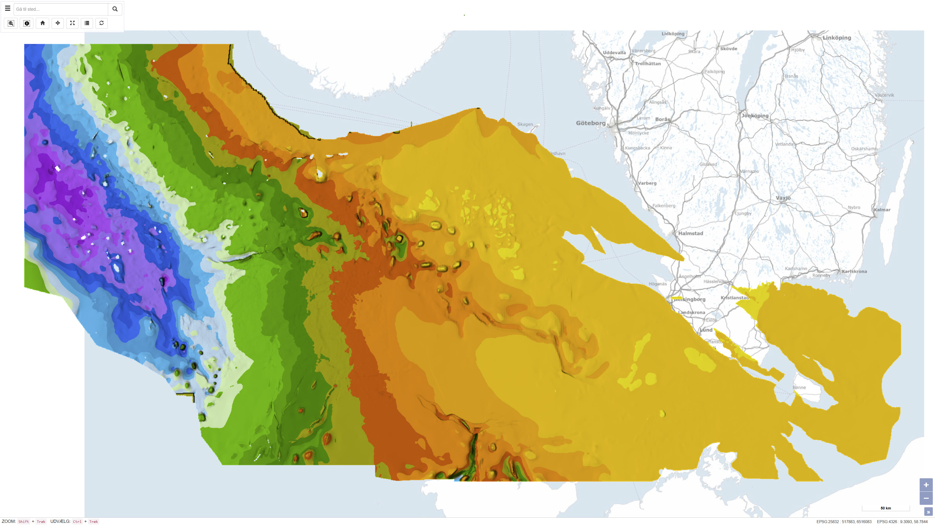
Datasættet beskriver strukturen og topografien af ’Top Kalk’-fladen, dvs. overgangen til toppen af kalkgruppen (inklusive Kridt og Danien) i den danske undergrund. Kortet viser de regionale variationer i dybde og struktur for kalkoverfladen fra central Nordsøen til de østlige danske områder, og det er baseret på en integreret geologisk og geofysisk fortolkning af seismiske profiler, boredata og tidligere kortlægninger. Kortet danner et vigtigt fundament for geologiske, geofysiske og reservoirstrategiske analyser i undergrunden.
This dataset represents the structure and topography of the Top Chalk surface, i.e. the top of the Chalk Group (including Upper Cretaceous to Danian), in the Danish subsurface. The map illustrates regional variations in the depth and structural configuration of the chalk surface from the central North Sea to the eastern Danish areas. It is based on an integrated geological and geophysical interpretation of seismic profiles, well data and earlier mapping. The map provides an essential basis for geological, geophysical and subsurface reservoir analyses.
Simple
Identifikation
- Titel
-
Top Kalk i den Danske Undergrund
Top Chalk surface in the Danish subsurface
Offentliggørelsestidspunkt
-
Dato (Publication)Dato (Publication)
- 2007-11-20
Ansvarlig myndighed og kontaktoplysninger
- Kontakt vedr. service
-
Organisationsnavn E-mail adresse Rolle De Nationale Geologiske Undersøgelser for Danmark og Grønland (GEUS)
The Geological Survey of Denmark and Greenland (GEUS)
Point of contactPoint of contact
- Metadata author
-
Organisationsnavn E-mail adresse Rolle De Nationale Geologiske Undersøgelser for Danmark og Grønland (GEUS)
The Geological Survey of Denmark and Greenland (GEUS)
Point of contactPoint of contact
Geografisk udstrækning
- Koordinatsystem
-
ETRS 89 / UTM 32N (EPSG:25832)
ETRS 89 / UTM 32N (EPSG:25832)
Nøgleord
-
NøgleordNøgleord
-
Datasæt
Dataset
-
NøgleordNøgleord
-
Geologi
Geology
-
NøgleordNøgleord
-
Top Kalk
Top Chalk
-
NøgleordNøgleord
-
Undergrund
Subsurface
-
NøgleordNøgleord
-
Danmark
Denmark
-
NøgleordNøgleord
-
Seismisk
Seismic
-
TypeType
-
ThemeTheme
-
NøgleordNøgleord
-
Geovidenskab og historiepolitikGeoscience and history policy
-
TypeType
-
ThemeTheme
-
Titel
-
Forskningsemner
-
Dato (Publication)Dato (Publication)
- 2025-11-03
-
NøgleordNøgleord
-
DanmarkDenmark
-
TypeType
-
PlacePlace
-
Titel
-
Geografisk
-
Dato (Publication)Dato (Publication)
- 2025-12-11
Kvalitet
-
Type som metadata beskriverType som metadata beskriver
-
DatasetDataset
-
BeskrivelseBeskrivelse
-
Datasættet er udviklet som en del af GEUS’ geologiske kortlægningsprojekter og blev omtalt i GEUS Bulletin nr. 13 i 2007, der offentliggjorde tre kort over kalken i Danmark: topfladen, bundfladen og isopake kort over kalkgruppen. Kortene er fremstillet ved integration af omfattende seismiske data, boredata fra mere end 500 dybe olie- og gasboringer samt kortlagte oplysninger fra vandboringer og tidligere kortlægninger. Interpretationerne er baseret på offentligt tilgængelige seismiske profiler og geologiske data samlet ind til og med begyndelsen af 2000’erne.
The dataset was developed as part of GEUS’s geological mapping initiatives and was described in GEUS Bulletin No. 13 (2007), which published three maps of chalk in Denmark: top chalk surface, base chalk surface, and an isopach map of the chalk group. The maps were produced by integrating extensive seismic data, well data from more than 500 deep oil and gas wells, and mapped information from water boreholes and previous geological interpretations. The interpretations are based on publicly available seismic profiles and geological data compiled up to the early 2000s.
)))
