 geodata-info
Geological cross sections in Greenland
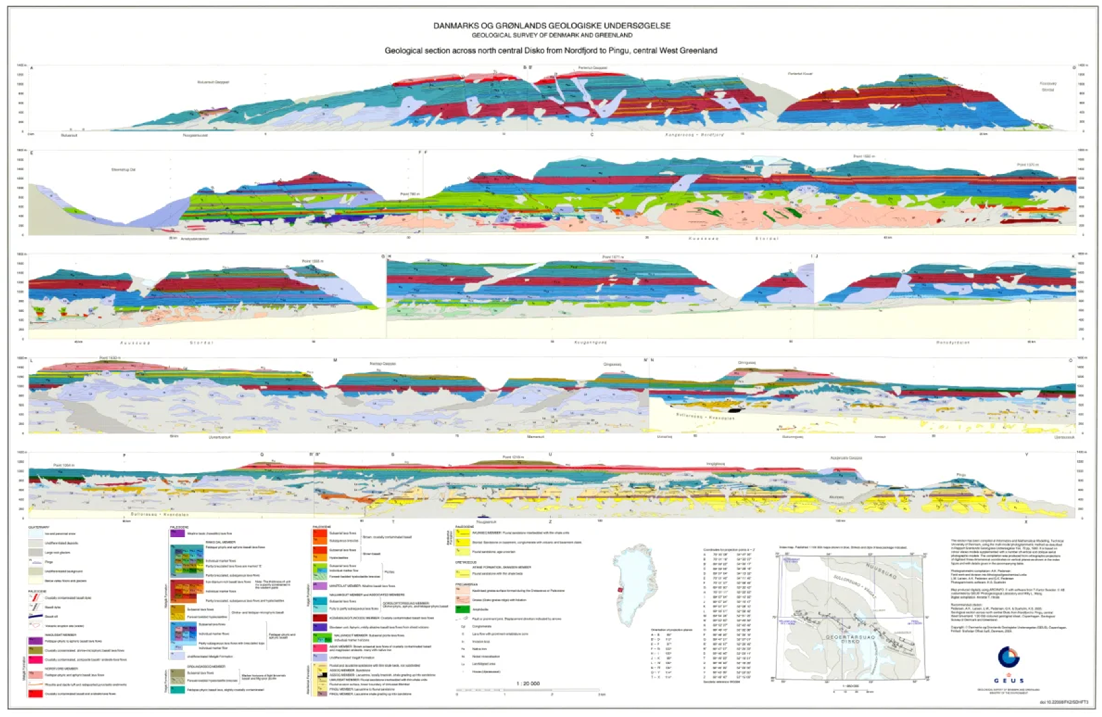
The dataset comprises a collection of geological cross sections from Greenland derived from multiple geological mapping projects and publications. The cross sections represent interpretations of subsurface geological structures and stratigraphy across selected regions and are associated with published geological maps and reports.
Profile lines have been georeferenced, and the corresponding cross-section images have been digitised and stored as separate PDF files. Each profile is linked to the geological map or publication from which it originates. Due to the diverse origins of the profiles, the level of detail, scale and geological interpretation vary between individual cross sections.
Simple
Identifikation
- Titel
-
Geological cross sections in Greenland
Offentliggørelsestidspunkt
- Dato (Publication)
- 2016-01-01
Ansvarlig myndighed og kontaktoplysninger
- Kontakt vedr. service
-
Organisationsnavn E-mail adresse Rolle The Geological Survey of Denmark and Greenland (GEUS)
Point of contact
- Metadata author
-
Organisationsnavn E-mail adresse Rolle The Geological Survey of Denmark and Greenland (GEUS)
Point of contact
Geografisk udstrækning
- Koordinatsystem
-
WGS 84 / UTM 24N (EPSG:32624)
Nøgleord
- Nøgleord
-
Dataset
- Nøgleord
-
Geology
- Nøgleord
-
Stratigraphy
- Nøgleord
-
Structural geology
- Nøgleord
-
Database
- Type
- Theme
- Nøgleord
- Tectonics and structural geology
- Nøgleord
- Stratigraphy and correlation
- Type
- Theme
- Titel
- Forskningsemner
- Dato (Publication)
- 2025-11-03
- Nøgleord
- Greenland
- Type
- Place
- Titel
- Geografisk
- Dato (Publication)
- 2025-12-11
Kvalitet
- Type som metadata beskriver
- Dataset
- Beskrivelse
-
The dataset is a compilation of geological cross sections originating from different geological mapping projects and published sources. The original cross sections were produced as part of individual geological studies and map publications, including regional geological mapping in Greenland.
For the present dataset, profile lines were georeferenced and the corresponding cross-section figures were digitised and stored as individual PDF files. Each profile retains references to its original source publication or geological map. No attempt has been made to harmonise geological interpretations or scales between the individual cross sections.
)))
