 geodata-info
Vertikale luftfotografier af Grønland 1:150.000
Vertical aerial photographs of Greenland 1:150.000
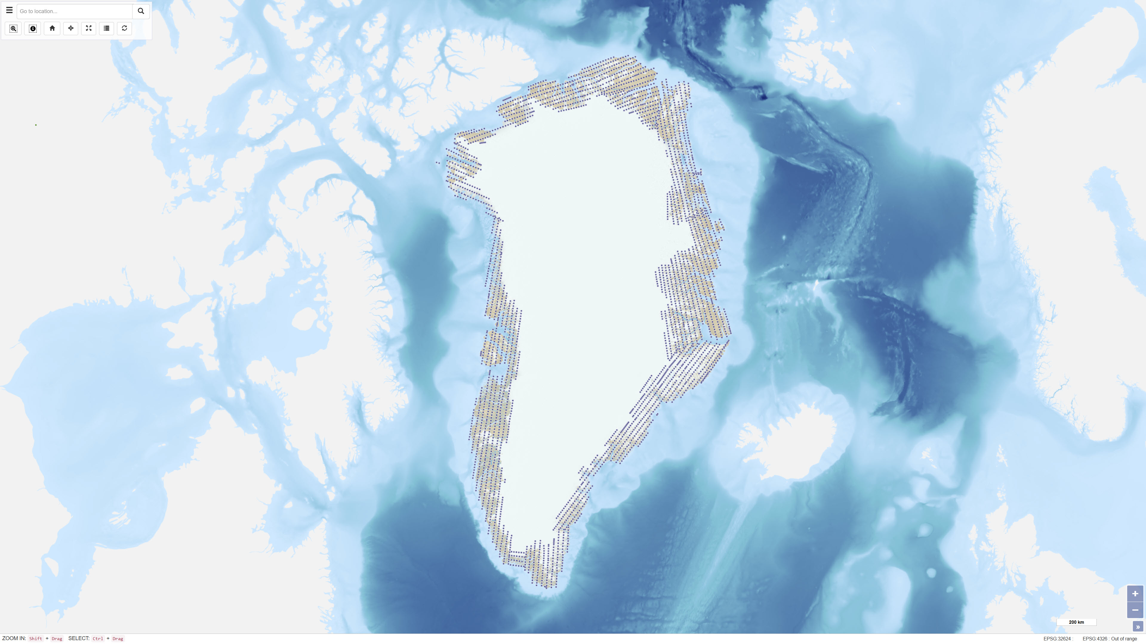
En ensartet vertikal luftfotodækning af Grønland blev gennemført i perioden 1978–1987 i målestok 1:150.000 af Mark Hurd Aerial Surveys, Inc., Minneapolis, Minnesota, U.S.A., på vegne af Danmarks Geodætiske Institut. Fotograferingen gav en systematisk landsdækkende dækning og udgør et grundlæggende referencedatasæt for kortlægning og geodætiske formål.
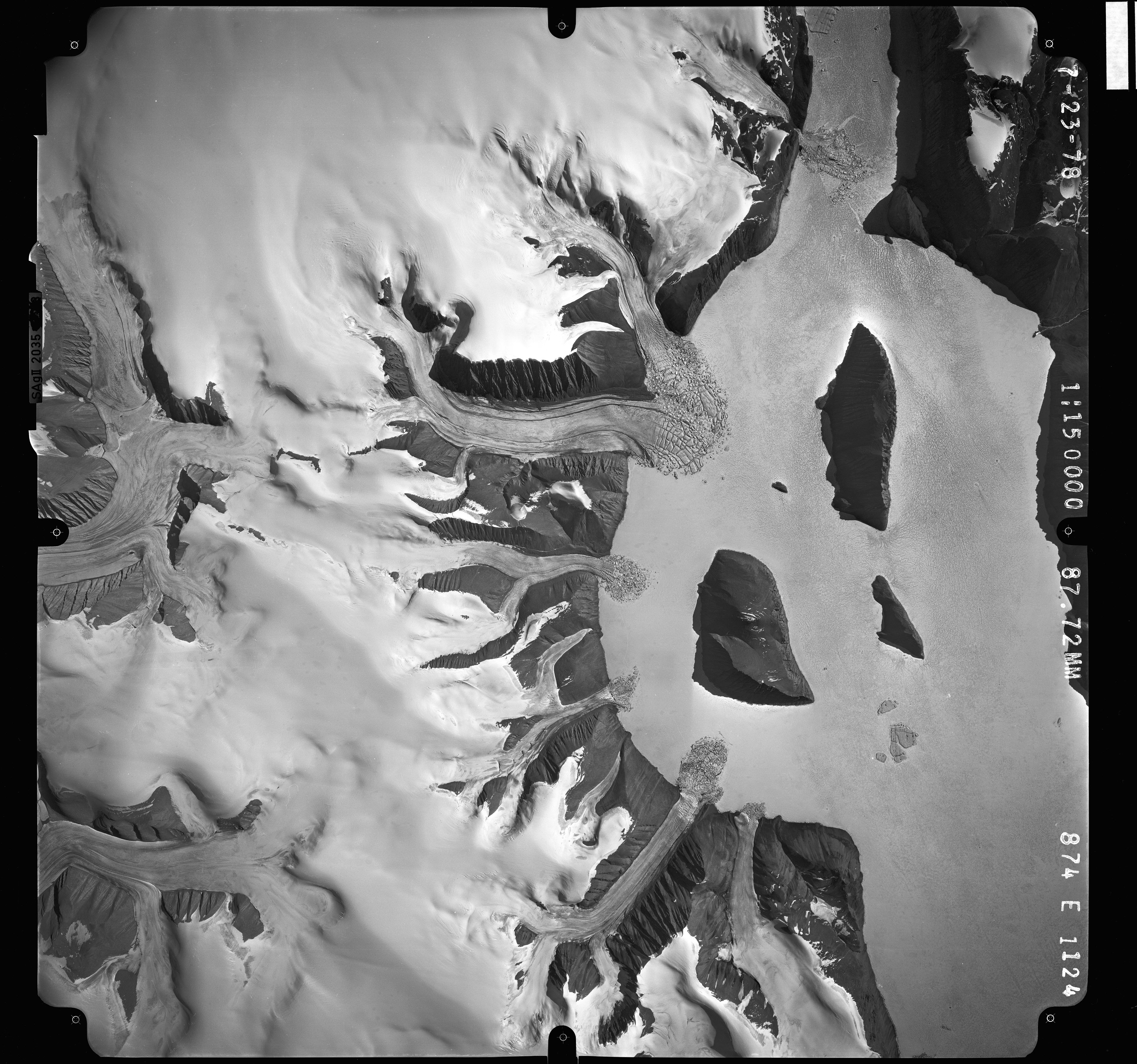
De sort-hvide fotografier blev optaget med et Wild RC-10 kamera udstyret med en supervidvinkellinse (brændvidde 88 mm). Flytypen var en Gates Learjet 25C, som fløj i cirka 14 km højde for at opnå målestokken 1:150.000. For at reducere blinde områder forårsaget af stejle bjergsider kombineret med vidvinkellinsen blev fotografierne optaget med 80% længdeoverlap og 40% sideoverlap.
Fotocentrenes koordinater er fastlagt ved aerotriangulering udført af Geodatastyrelsen. Datasættet har efterfølgende været anvendt til kortlægning, aerotriangulering og digital scanning.
Uniform vertical aerial photographic coverage of Greenland was achieved between 1978 and 1987 at a scale of 1:150.000 by Mark Hurd Aerial Surveys, Inc., Minneapolis, Minnesota, U.S.A., on behalf of the Danish Geodetic Institute. The photography provided systematic nationwide coverage and formed a fundamental reference dataset for mapping and geodetic purposes.
The black-and-white photographs were acquired using a Wild RC-10 camera equipped with a super wide-angle lens (focal length 88 mm). The aircraft used was a Gates Learjet 25C, flying at approximately 14 km altitude to achieve the image scale of 1:150.000. To minimise blind areas caused by steep mountain slopes in combination with the wide-angle lens, photographs were acquired with 80% forward overlap and 40% side overlap.
Photo centre coordinates were established through aerotriangulation performed by the Danish Geodata Agency. The dataset has subsequently been used for mapping, aerotriangulation and scanning applications.
Simple
Identifikation
- Titel
-
Vertikale luftfotografier af Grønland 1:150.000
Vertical aerial photographs of Greenland 1:150.000
Offentliggørelsestidspunkt
-
Dato (Publication)Dato (Publication)
- 2023-12-03
Ansvarlig myndighed og kontaktoplysninger
- Kontakt vedr. service
-
Organisationsnavn E-mail adresse Rolle De Nationale Geologiske Undersøgelser for Danmark og Grønland (GEUS)
The Geological Survey of Denmark and Greenland (GEUS)
Point of contactPoint of contact
- Metadata author
-
Organisationsnavn E-mail adresse Rolle De Nationale Geologiske Undersøgelser for Danmark og Grønland (GEUS)
The Geological Survey of Denmark and Greenland (GEUS)
Point of contactPoint of contact
Geografisk udstrækning
- Koordinatsystem
-
WGS 84 / UTM 24N (EPSG:32624)
WGS 84 / UTM 24N (EPSG:32624)
Nøgleord
-
NøgleordNøgleord
-
Datasæt
Dataset
-
NøgleordNøgleord
-
Vertikale luftfotografier
Vertical aerial photographs
-
NøgleordNøgleord
-
Luftfotografering
Aerial photography
-
NøgleordNøgleord
-
Fotogrammetri
Photogrammetry
-
NøgleordNøgleord
-
Grønland
Greenland
-
TypeType
-
ThemeTheme
-
NøgleordNøgleord
-
Geovidenskab og historiepolitikGeoscience and history policy
-
TypeType
-
ThemeTheme
-
Titel
-
Forskningsemner
-
Dato (Publication)Dato (Publication)
- 2025-11-03
-
NøgleordNøgleord
-
GrønlandGreenland
-
TypeType
-
PlacePlace
-
Titel
-
Geografisk
-
Dato (Publication)Dato (Publication)
- 2025-12-11
Kvalitet
-
Type som metadata beskriverType som metadata beskriver
-
DatasetDataset
-
BeskrivelseBeskrivelse
-
Luftfotografierne blev optaget i perioden 1978–1987 af Mark Hurd Aerial Surveys, Inc. for Danmarks Geodætiske Institut som led i et nationalt luftfotoprogram. Undersøgelsen havde til formål at opnå fuldstændig fotografisk dækning af Grønland i en ensartet målestok på 1:150.000.
Fotografierne blev optaget med systematisk længde- og sideoverlap for at sikre stereoskopisk dækning og minimere blinde områder. Efterfølgende aerotriangulering blev udført af Geodatastyrelsen for at fastlægge præcise fotocenterkoordinater. Datasættet har siden fungeret som grundlag for kortlægnings-, geodætiske og geovidenskabelige anvendelser.
The aerial photographs were acquired between 1978 and 1987 by Mark Hurd Aerial Surveys, Inc. for the Danish Geodetic Institute as part of a national aerial photography programme. The survey was designed to provide complete photographic coverage of Greenland at a uniform scale of 1:150,000.
The photographs were acquired with systematic forward and side overlap to ensure stereoscopic coverage and minimise blind areas. Subsequent aerotriangulation was performed by the Danish Geodata Agency to establish accurate photo centre coordinates. The dataset has since been used as a basis for mapping, geodetic and geoscientific applications.
)))
