 geodata-info
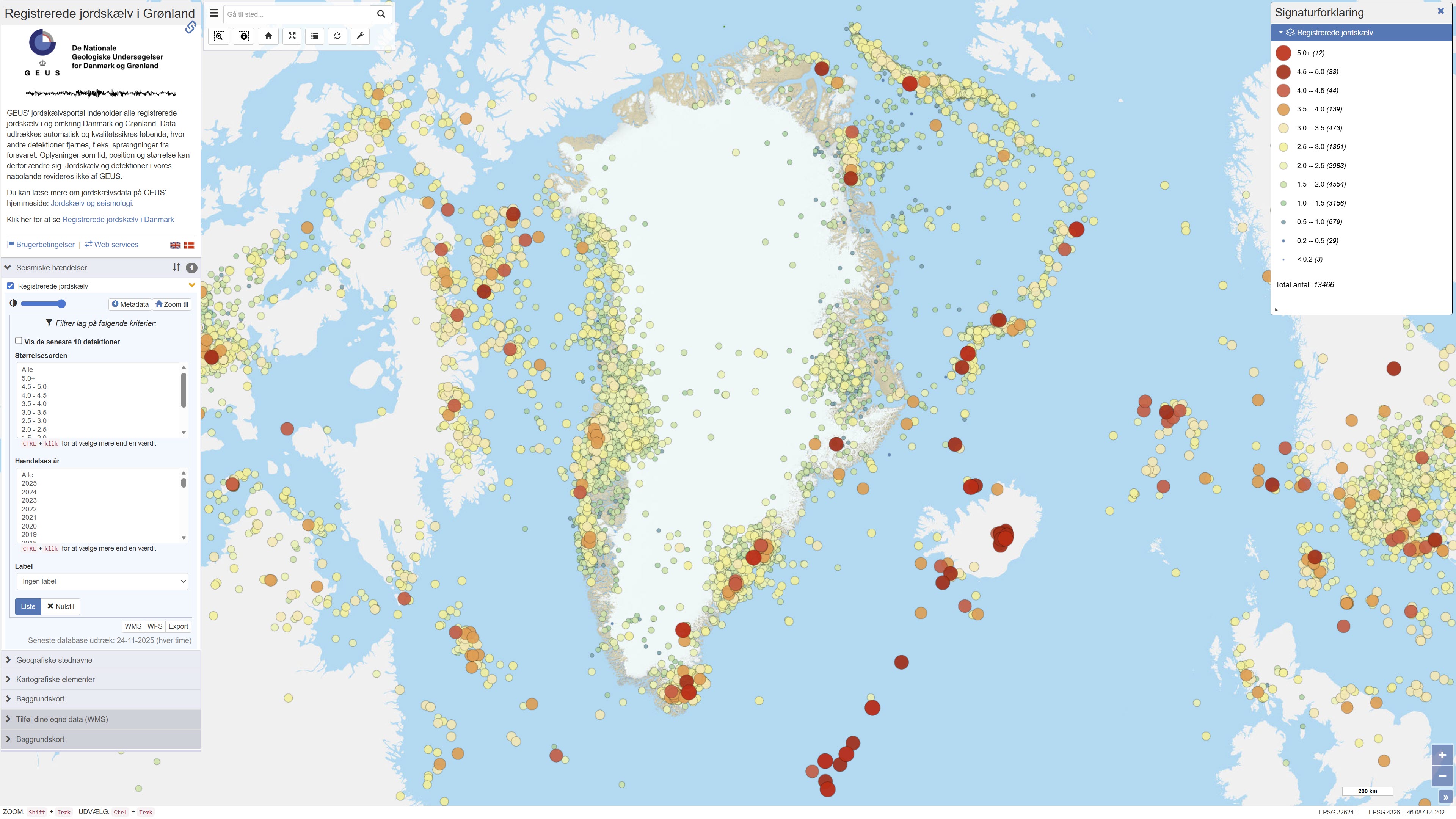
Recorded earthquakes in Greenland
The dataset contains recorded earthquakes and seismic events in Greenland. The data include information on event time, geographic location (epicentre), depth and magnitude for confirmed and suspected earthquakes. The dataset is based on observations from GEUS’ seismic monitoring network and is used for monitoring, research and dissemination of seismic activity in Greenland.
Simple
Identifikation
- Titel
-
Recorded earthquakes in Greenland
Offentliggørelsestidspunkt
- Dato (Publication)
- 2025-05-20
Ansvarlig myndighed og kontaktoplysninger
- Kontakt vedr. service
-
Organisationsnavn E-mail adresse Rolle The Geological Survey of Denmark and Greenland (GEUS)
Point of contact The Geological Survey of Denmark and Greenland (GEUS)
Author The Geological Survey of Denmark and Greenland (GEUS)
Custodian The Geological Survey of Denmark and Greenland (GEUS)
Custodian The Geological Survey of Denmark and Greenland (GEUS)
Publisher
- Metadata author
-
Organisationsnavn E-mail adresse Rolle The Geological Survey of Denmark and Greenland (GEUS)
Point of contact
Geografisk udstrækning
- Koordinatsystem
-
WGS 84 / UTM 24N (EPSG:32624)
Nøgleord
- Nøgleord
-
Dataset
- Nøgleord
-
Seismology
- Nøgleord
-
Earthquake
- Nøgleord
-
Database
- Type
- Theme
- Nøgleord
- Tectonics and structural geology
- Nøgleord
- Geoscience and history policy
- Type
- Theme
- Titel
- Forskningsemner
- Dato (Publication)
- 2025-11-03
- Nøgleord
- Denmark
- Type
- Place
- Titel
- Geografisk
- Dato (Publication)
- 2025-12-11
Kvalitet
- Type som metadata beskriver
- Dataset
- Beskrivelse
-
The dataset is based on data from GEUS’ seismic monitoring network in Greenland. Earthquakes are recorded using seismographs and analysed to determine event time, location, depth and magnitude. The data form part of both national and international seismic monitoring and are updated continuously. Quality control is performed to identify and exclude non-seismic events, such as explosions, where possible. The dataset includes both confirmed and suspected earthquakes.
)))
