 geodata-info
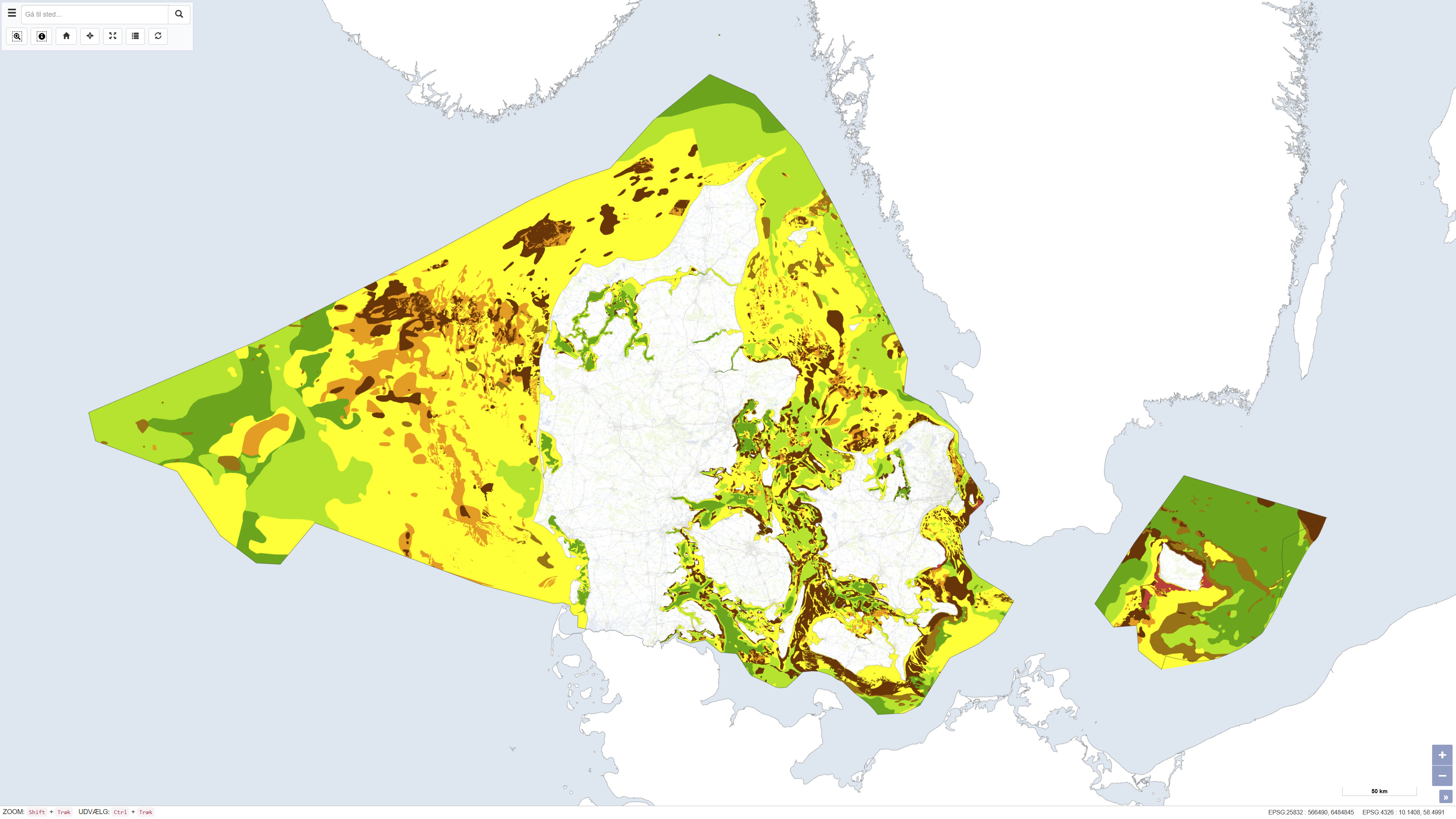
Seabed Sediment Map of Denmark
The seabed sediment map shows the distribution of seabed sediments in Danish waters and represents an integrated interpretation of sediment types within the upper approximately 0.5 metres of the seabed. Sediment classes are defined based on grain-size composition and reflect an average of the surface sediments. Glacial till is classified as a mixed sediment, while sedimentary bedrock indicates areas where deposits several million years old are exposed on the seabed.
The map was updated in 2020 and builds upon the previous version from 2014, with newly mapped areas added at full level of detail. The dataset provides a nationwide overview of seabed sedimentary conditions and is used, among other purposes, for raw material mapping, marine spatial planning, and environmental assessments.
Simple
Identifikation
- Titel
-
Seabed Sediment Map of Denmark
Offentliggørelsestidspunkt
- Dato (Publication)
- 2020-01-01
Ansvarlig myndighed og kontaktoplysninger
- Kontakt vedr. service
-
Organisationsnavn E-mail adresse Rolle The Geological Survey of Denmark and Greenland (GEUS)
Point of contact
- Metadata author
-
Organisationsnavn E-mail adresse Rolle The Geological Survey of Denmark and Greenland (GEUS)
Point of contact
Geografisk udstrækning
- Koordinatsystem
-
ETRS 89 / UTM 32N (EPSG:25832)
Nøgleord
- Nøgleord
-
Dataset
- Nøgleord
-
Marine geology
- Nøgleord
-
Seabed sediments
- Nøgleord
-
Raw materials
- Nøgleord
-
Denmark
- Nøgleord
-
ArcGIS
- Nøgleord
-
QGIS
- Type
- Theme
- Nøgleord
- Sedimentary rocks and processes
- Nøgleord
- Soils and biogeochemistry
- Type
- Theme
- Titel
- Forskningsemner
- Dato (Publication)
- 2025-11-03
- Nøgleord
- Denmark
- Type
- Place
- Titel
- Geografisk
- Dato (Publication)
- 2025-12-11
Kvalitet
- Type som metadata beskriver
- Dataset
- Beskrivelse
-
The map is primarily based on seismic and acoustic background data calibrated using seabed sediment samples. Data coverage varies significantly across Danish waters, and interpretations therefore rely extensively on interpolation between data points. Geological knowledge of sedimentary formation processes, together with detailed bathymetric data, has been used to delineate sediment boundaries. In addition, biological information on the distribution of benthic algae, eelgrass, and mussels has been incorporated as supplementary evidence, as these organisms provide indirect indications of seabed substrate. The 2020 version represents an update of the 2014 map, with newly mapped areas added at full mapping detail.
)))
