 geodata-info
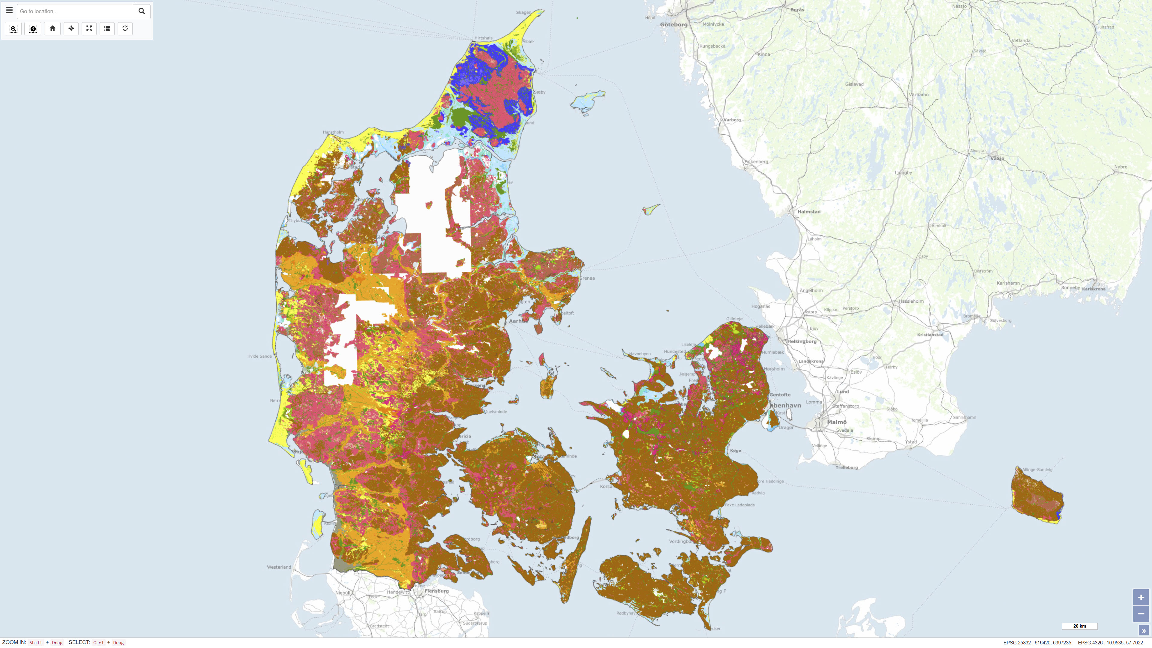
Geological surface map of Denmark 1:25.000
The Digital Geological Map of Denmark 1:25,000, version 7.0, is a nationwide geological dataset describing the distribution of near-surface soil and sediment types across Denmark. The dataset is produced and maintained by the Geological Survey of Denmark and Greenland (GEUS) and represents the latest version of the digital soil and sediment map at a scale of 1:25,000.
The map is based on an integrated interpretation of geological field observations, borehole data, historical analogue maps, and more recent digital datasets. Soil and sediment units are classified according to their lithological and genetic characteristics and represent the dominant materials in the uppermost geological layers. The dataset is continuously updated, and version 7.0 includes both revisions of previously mapped areas and newly mapped regions.
The dataset is widely used as a foundation for geological analysis, land-use planning, environmental assessment, groundwater protection, raw material management, research, and education.
In version 7 from 2023, 93% of Denmark's land area is classified, and the map is continuously supplemented. The map and sediment type description are published in GEUS report 2023/29, where further information is available.
Simple
Identifikation
- Titel
-
Geological surface map of Denmark 1:25.000
Offentliggørelsestidspunkt
- Dato (Publication)
- 2024-01-17
Ansvarlig myndighed og kontaktoplysninger
- Kontakt vedr. service
-
Organisationsnavn E-mail adresse Rolle The Geological Survey of Denmark and Greenland (GEUS)
Point of contact
- Metadata author
-
Organisationsnavn E-mail adresse Rolle The Geological Survey of Denmark and Greenland (GEUS)
Point of contact
Geografisk udstrækning
- Koordinatsystem
-
ETRS 89 / UTM 32N (EPSG:25832)
Nøgleord
- Nøgleord
-
Dataset
- Nøgleord
-
Geology
- Nøgleord
-
Soils
- Nøgleord
-
Mapping
- Nøgleord
-
Denmark
- Nøgleord
-
ArcGIS
- Nøgleord
-
QGIS
- Type
- Theme
- Nøgleord
- Sedimentary rocks and processes
- Nøgleord
- Quaternary geology
- Type
- Theme
- Titel
- Forskningsemner
- Dato (Publication)
- 2025-11-03
- Nøgleord
- Denmark
- Type
- Place
- Titel
- Geografisk
- Dato (Publication)
- 2025-12-11
Kvalitet
- Type som metadata beskriver
- Dataset
- Beskrivelse
-
The Digital Geological Map version 7.0 is the product of a long-term geological data acquisition and mapping program in Denmark. Field surveys and geological observations were carried out from approximately 1888 up to the publication year of 2023. The map is based on compiled geological data from interpreted field maps, boreholes, and systematic digitization of historical analogue maps. Version 7 includes additional mapped areas beyond earlier versions and was produced by the Geological Survey of Denmark and Greenland (GEUS).
)))
