 geodata-info
INSPIRE - Radardata fra DMI
INSPIRE - Weather Radar Data from DMI
DMI observerer nedbør med radarer i og nær dansk område. DMI’s målernetværket består af fem radarer placeret ved Stevns Naturcenter, Rømø, i Sindal i Vendsyssel, Almindingen på Bornholm og i Virring i Østjylland.
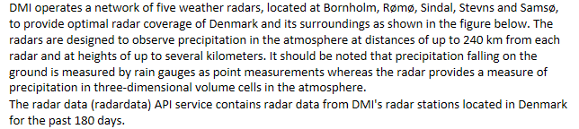
DMI operates a network of five weather radars, located at Bornholm, Rømø, Sindal, Stevns and Samsø, to provide optimal radar coverage of Denmark and its surroundings as shown in the figure below. The radars are designed to observe precipitation in the atmosphere at distances of up to 240 km from each radar and at heights of up to several kilometers. It should be noted that precipitation falling on the ground is measured by rain gauges as point measurements whereas the radar provides a measure of precipitation in three-dimensional volume cells in the atmosphere.
The radar data (radardata) API service contains radar data from DMI's radar stations located in Denmark for the past 180 days.
)))