 geodata-info
Geological surface map of Denmark 1:200.000
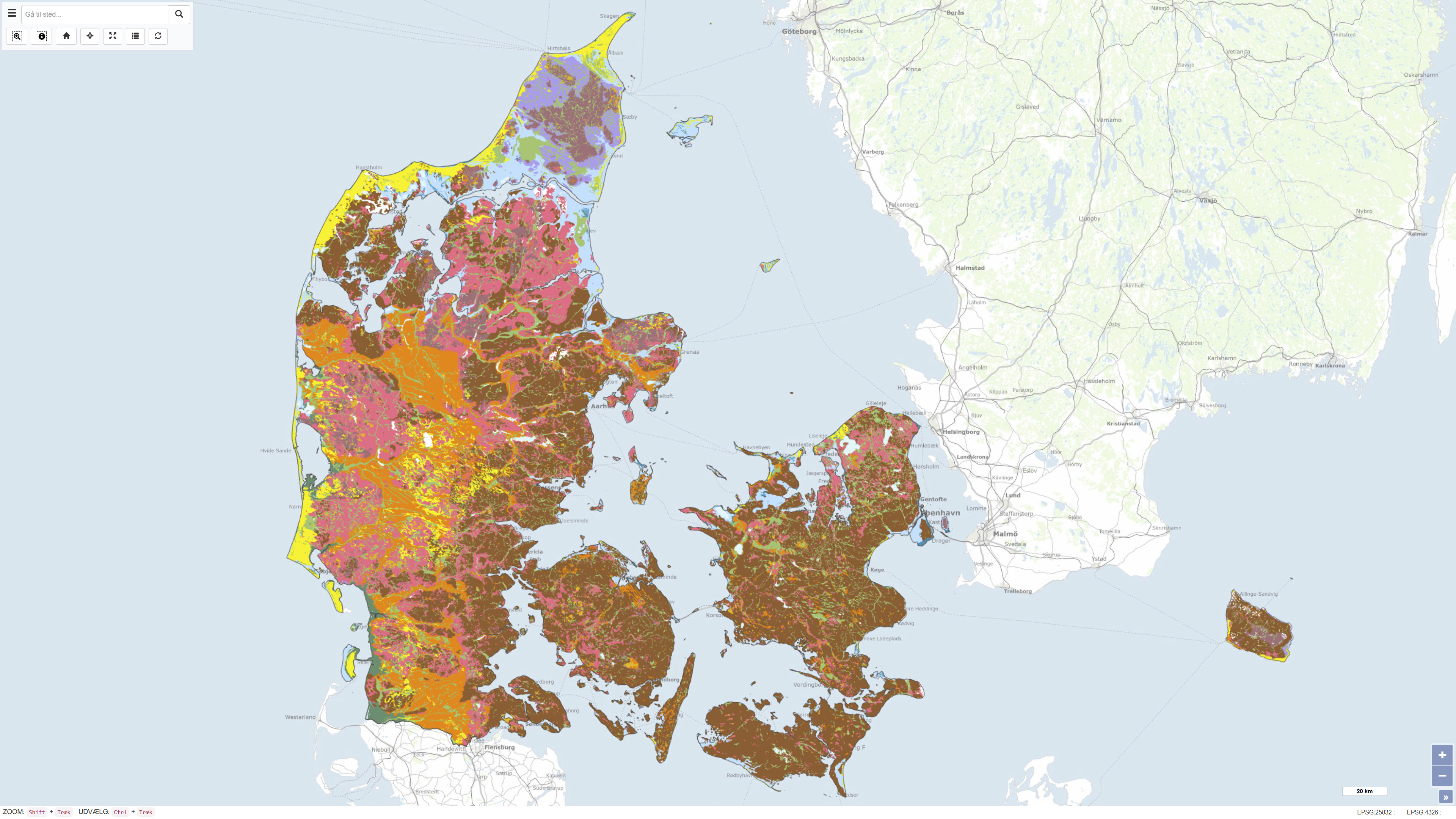
This dataset represents a nationwide digital geological map of superficial deposits in Denmark at a scale of 1:200.000. The map shows the classification and distribution of near-surface deposits, primarily glacial and post-glacial sediments. The dataset is based on the Digital Soil and Sediment Map of Denmark at 1:25.000 in areas where detailed mapping is available. In other areas, the distribution of deposits has been interpreted based on borehole data, landscape analysis and other available geological information. The deposits are classified into 12 generalised types, making the dataset a simplified and generalised version of the detailed 1:25.000 map. The dataset provides a national overview of superficial deposits and serves as a reference for regional and national applications.
Simple
Identifikation
- Titel
-
Geological surface map of Denmark 1:200.000
Offentliggørelsestidspunkt
- Dato (Publication)
- 2011-10-09
Ansvarlig myndighed og kontaktoplysninger
- Kontakt vedr. service
-
Organisationsnavn E-mail adresse Rolle The Geological Survey of Denmark and Greenland (GEUS)
Point of contact
- Metadata author
-
Organisationsnavn E-mail adresse Rolle The Geological Survey of Denmark and Greenland (GEUS)
Point of contact
Geografisk udstrækning
- Koordinatsystem
-
ETRS 89 / UTM 32N (EPSG:25832)
Nøgleord
- Nøgleord
-
Dataset
- Nøgleord
-
Geology
- Nøgleord
-
Soil
- Nøgleord
-
Quaternary
- Nøgleord
-
Surface
- Nøgleord
-
Denmark
- Nøgleord
-
ArcGIS
- Type
- Theme
- Nøgleord
- Soils and biogeochemistry
- Nøgleord
- Geoscience and history policy
- Nøgleord
- Quaternary geology
- Type
- Theme
- Titel
- Forskningsemner
- Dato (Publication)
- 2025-11-03
- Nøgleord
- Denmark
- Type
- Place
- Titel
- Geografisk
- Dato (Publication)
- 2025-12-11
Kvalitet
- Type som metadata beskriver
- Dataset
- Beskrivelse
-
The dataset was compiled by the Geological Survey of Denmark and Greenland (GEUS) and represents version 2 of the digital superficial deposits map at a scale of 1:200.000. The map is based on the compilation and harmonisation of existing geological maps, borehole data, geomorphological analyses and previous Quaternary geological investigations. Version 2 includes updates and improvements compared to earlier versions, including revised deposit boundaries and classifications based on new knowledge and quality assurance.
During compilation of the dataset, generalisation and adjustments have been applied in certain areas, resulting in a spatial uncertainty of up to approximately 200 m, locally slightly more. The dataset is designed as an overview map at a scale of 1:200.000 and is suitable for educational purposes, regional-scale analyses and as background information for other thematic maps. The dataset is not subject to continuous updates and was published in GEUS Report 2011/19.
Mapping of superficial deposits in Denmark has been a core task of the Danish geological surveys since the establishment of the Geological Survey of Denmark (DGU) in 1888. The digital superficial deposits map at a scale of 1:200.000, version 2, builds on this long mapping tradition but represents a modern digital compilation and interpretation based on more recent data and methods.
)))
