 geodata-info
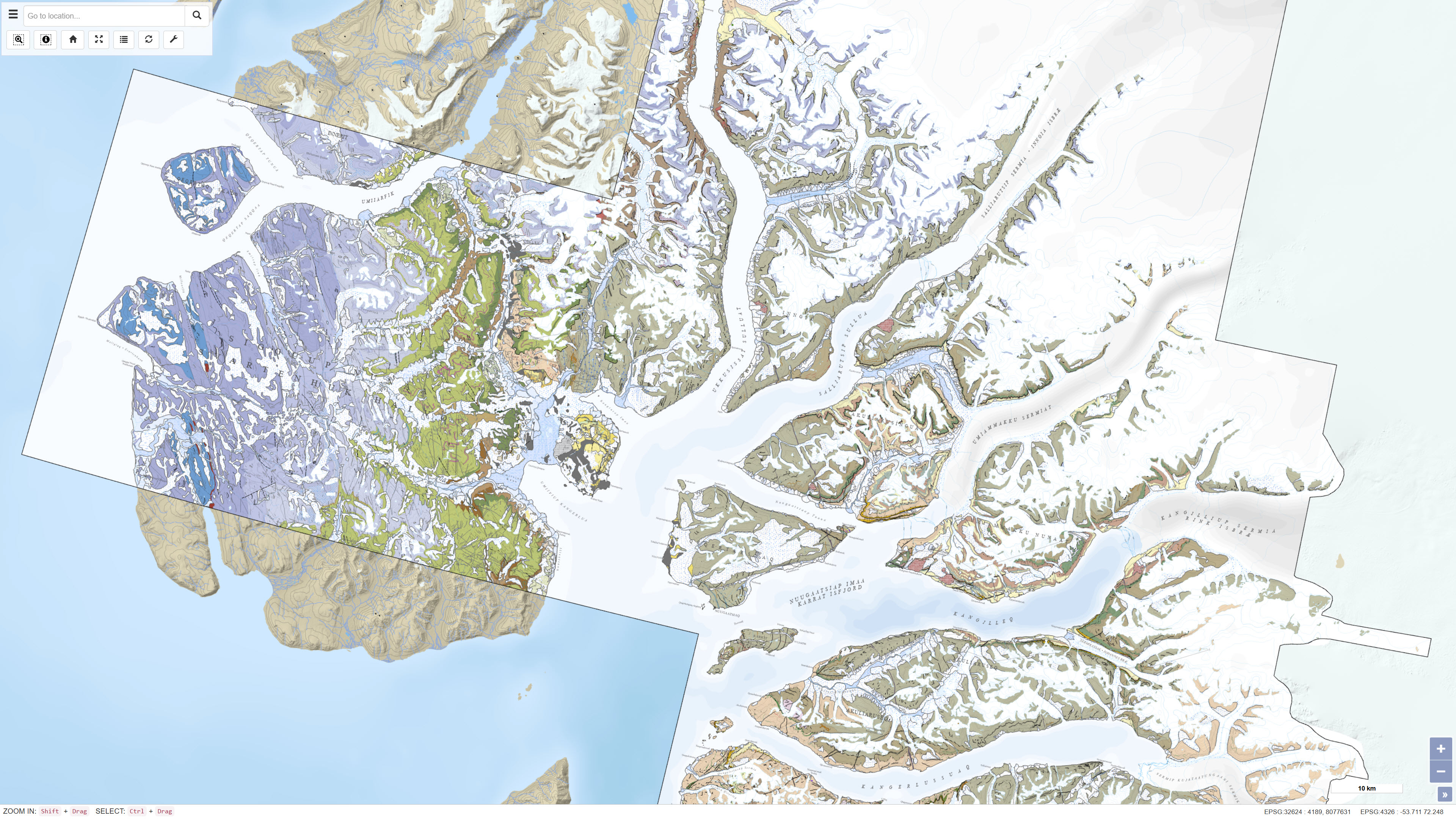
Geologisk kort over Karrat-området 1:100.000
Geological map of the Karrat area 1:100 000
Dette datasæt indeholder et sømløst digitalt geologisk kort over Karrat-området i det centrale Vestgrønland baseret på fire geologiske kortblade i målestok 1:100.000: Maarmorilik 71 V.2 Syd, Nuugaatsiaq 71 V.2 Nord, Pannertooq 72 V.2 Syd og Svartenhuk 71 V.1 Nord. Kortlægningen er udført i fjordområderne nord for Uummannaq som led i et samarbejde mellem De Nationale Geologiske Undersøgelser for Danmark og Grønland (GEUS) og Grønlands Departement for Råstoffer og Justitsområdet. Datasættet er baseret på 3D-fotogeologi ved anvendelse af mere end 35.000 skråfotografier indsamlet gennem tre feltsæsoner kombineret med traditionelle feltobservationer samt efterfølgende geokemiske og geokronologiske analyser. Datasættet giver en opdateret geologisk forståelse af Karrat-gruppens meta-sedimentære og meta-vulkanske bjergarter, den strukturelle udvikling af Rinkian Orogen samt strukturen af West Greenland Basalt Group. Datasættet kan anvendes til geologisk forskning, regional geologisk kortlægning og mineralefterforskning.
This dataset contains a seamless digital geological map of the Karrat area in central West Greenland based on four geological map sheets at a scale of 1:100 000: Maarmorilik 71 V.2 South, Nuugaatsiaq 71 V.2 North, Pannertooq 72 V.2 South and Svartenhuk 71 V.1 North. Geological mapping was carried out in the fjord regions north of Uummannaq as part of a collaborative project between the Geological Survey of Denmark and Greenland (GEUS) and the Ministry of Mineral Resources and Justice of Greenland. The dataset is based on 3D photogeology using more than 35,000 oblique photographs collected during three field seasons combined with traditional field observations and subsequent geochemical and geochronological analyses. The dataset provides an updated geological understanding of the meta-sedimentary and meta-volcanic rocks of the Karrat Group, the structural evolution of the Rinkian Orogen and the structure of the West Greenland Basalt Group. The dataset supports geological research, regional geological mapping and mineral exploration.
Simple
Identifikation
- Titel
-
Geologisk kort over Karrat-området 1:100.000
Geological map of the Karrat area 1:100 000
Offentliggørelsestidspunkt
-
Dato (Publication)Dato (Publication)
- 2025-01-01
Ansvarlig myndighed og kontaktoplysninger
- Kontakt vedr. service
-
Organisationsnavn E-mail adresse Rolle De Nationale Geologiske Undersøgelser for Danmark og Grønland (GEUS)
The Geological Survey of Denmark and Greenland (GEUS)
Point of contactPoint of contact
- Metadata author
-
Organisationsnavn E-mail adresse Rolle De Nationale Geologiske Undersøgelser for Danmark og Grønland (GEUS)
The Geological Survey of Denmark and Greenland (GEUS)
Point of contactPoint of contact
Geografisk udstrækning
- Koordinatsystem
-
WGS 84 / UTM 24N (EPSG:32624)
WGS 84 / UTM 24N (EPSG:32624)
Nøgleord
-
NøgleordNøgleord
-
Datasæt
Dataset
-
NøgleordNøgleord
-
Geologi
Geology
-
NøgleordNøgleord
-
Geologiske kort
Geological maps
-
NøgleordNøgleord
-
Karrat
Karrat
-
NøgleordNøgleord
-
Vestgrønland
West Greenland
-
NøgleordNøgleord
-
Stratigrafi
Stratigraphy
-
NøgleordNøgleord
-
Strukturgeologi
Structural geology
-
TypeType
-
ThemeTheme
-
NøgleordNøgleord
-
Tektonik og strukturgeologiTectonics and structural geology
-
NøgleordNøgleord
-
Stratigrafi og korrelationStratigraphy and correlation
-
TypeType
-
ThemeTheme
-
Titel
-
Forskningsemner
-
Dato (Publication)Dato (Publication)
- 2025-11-03
-
NøgleordNøgleord
-
GrønlandGreenland
-
TypeType
-
PlacePlace
-
Titel
-
Geografisk
-
Dato (Publication)Dato (Publication)
- 2025-12-11
Kvalitet
-
Type som metadata beskriverType som metadata beskriver
-
DatasetDataset
-
BeskrivelseBeskrivelse
-
Datasættet er baseret på geologisk kortlægning udført af GEUS i samarbejde med Grønlands Departement for Råstoffer og Justitsområdet i fjordområderne nord for Uummannaq i det centrale Vestgrønland. Kortlægningen omfattede 3D-fotogeologiske analyser baseret på mere end 35.000 skråfotografier indsamlet gennem tre feltsæsoner kombineret med traditionelle feltobservationer. Derudover blev mere end 700 prøver analyseret geokemisk og næsten 100 prøver analyseret geokronologisk. Datasættet sammenstiller og harmoniserer fire geologiske kortblade i målestok 1:100.000 til ét sømløst digitalt kortprodukt.
The dataset is based on geological mapping carried out by GEUS in collaboration with the Ministry of Mineral Resources and Justice of Greenland in the fjord regions north of Uummannaq in central West Greenland. Mapping included 3D photogeological interpretation based on more than 35,000 oblique photographs collected during three field seasons combined with traditional field observations. In addition, more than 700 samples were analysed for geochemistry and nearly 100 samples were analysed for geochronology. The dataset compiles and harmonises four geological map sheets at a scale of 1:100 000 into a seamless digital map product.
)))
