 geodata-info
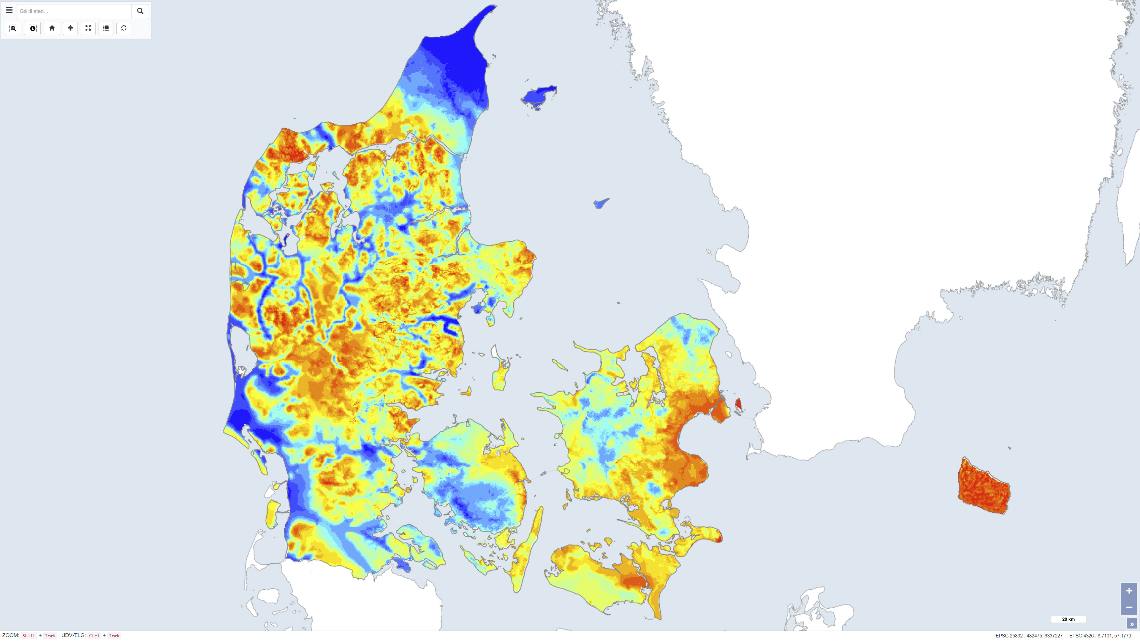
Quaternary thickness of Denmark
The dataset shows the thickness of Quaternary deposits in Denmark. The thickness has been calculated as the difference between surface elevation and the depth to the top of the pre-Quaternary deposits. The map provides a nationwide overview of variations in Quaternary thickness and is used in geological, hydrogeological and planning-related contexts.
Simple
Identifikation
- Titel
-
Quaternary thickness of Denmark
Offentliggørelsestidspunkt
- Dato (Publication)
- 2012-02-07
Ansvarlig myndighed og kontaktoplysninger
- Kontakt vedr. service
-
Organisationsnavn E-mail adresse Rolle The Geological Survey of Denmark and Greenland (GEUS)
Point of contact
- Metadata author
-
Organisationsnavn E-mail adresse Rolle The Geological Survey of Denmark and Greenland (GEUS)
Point of contact
Geografisk udstrækning
- Koordinatsystem
-
ETRS 89 / UTM 32N (EPSG:25832)
Nøgleord
- Nøgleord
-
Dataset
- Nøgleord
-
Quaternary deposits
- Nøgleord
-
Quaternary thickness
- Nøgleord
-
Subsurface
- Nøgleord
-
Geology
- Nøgleord
-
Denmark
- Nøgleord
-
ArcGIS
- Nøgleord
-
QGIS
- Type
- Theme
- Nøgleord
- Quaternary geology
- Nøgleord
- Sedimentary rocks and processes
- Type
- Theme
- Titel
- Forskningsemner
- Dato (Publication)
- 2025-11-03
- Nøgleord
- Denmark
- Type
- Place
- Titel
- Geografisk
- Dato (Publication)
- 2025-12-11
Kvalitet
- Type som metadata beskriver
- Dataset
- Beskrivelse
-
The dataset was produced by combining a digital terrain model with information on the depth to the top of the pre-Quaternary deposits. The terrain model is based on the national elevation model from the National Survey and Cadastre (2008), while the depth to the pre-Quaternary surface is derived from geological interpretations, including borehole data and existing geological maps. The thickness of the Quaternary deposits has been calculated as the difference between these two surfaces. The dataset represents a generalized, nationwide interpretation reflecting the available data and methods at the time of compilation.
)))
