 geodata-info
Geologisk kort over Danmark, 1:200.000 - Den danske Centralgrav: Top Kalk og Post Kalk Gruppen
Geological map of Denmark, 1:200,000 - The Danish Central Graben: Top Chalk and Post-Chalk Group
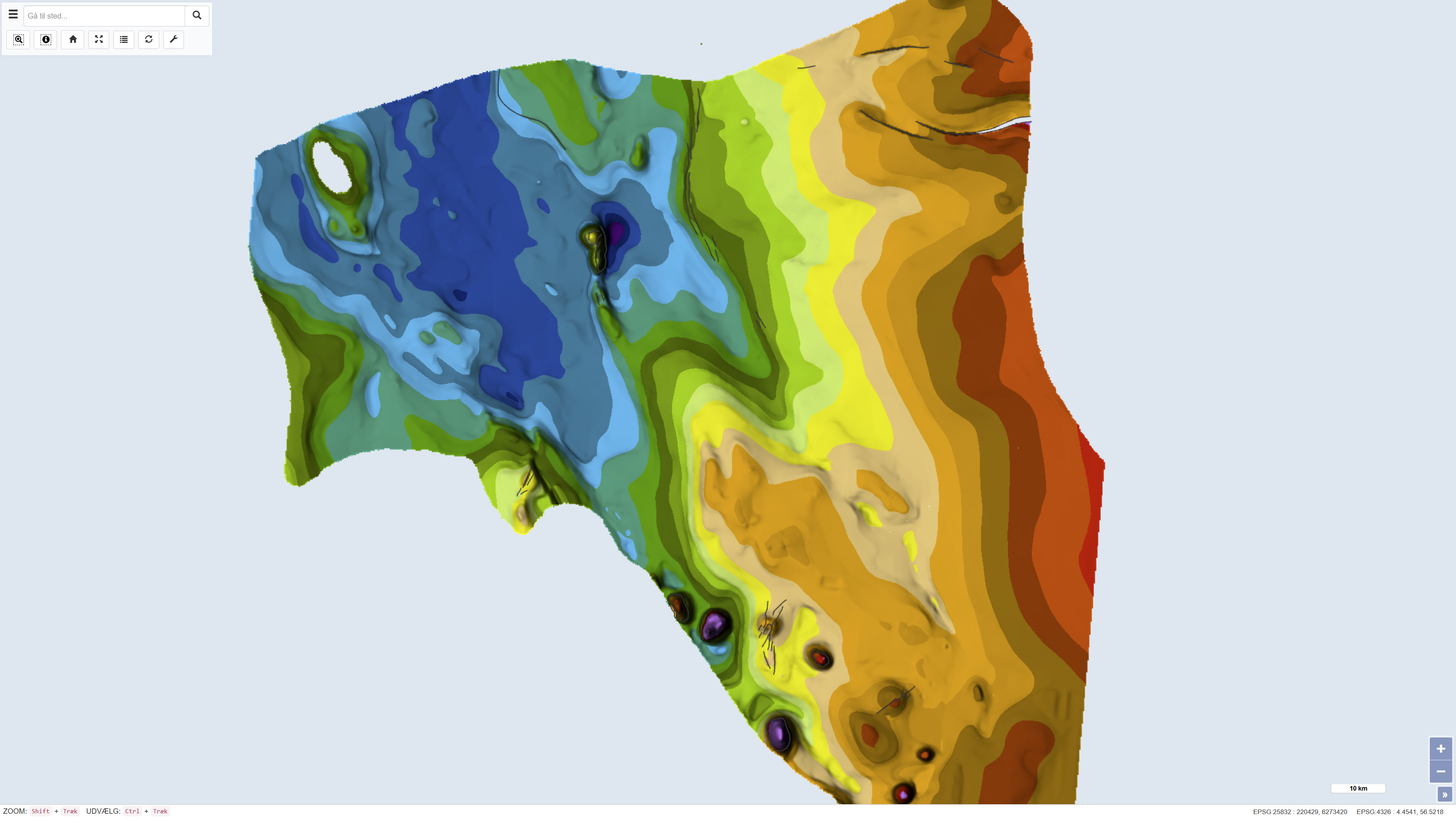
Datasættet omfatter et geologisk kort over Den danske Centralgrav i målestok 1:200.000, som præsenterer regionale kort for ‘Top Kalk’ og Post Kalk Gruppen i form af two-way travel time, dybde og intervalhastighed. Kortet er publiceret i 1995 som en del af DGU Kortserie nr. 47 og er udarbejdet som led i en samlet geologisk kortlægning af Den danske Centralgrav.
Kortlægningen er baseret på tolkning af seismiske data suppleret med oplysninger fra boringer. Kortet dækker den danske del af Centralgraven samt dele af den østlige Nordsøblok, og nærliggende områder i norsk, britisk og tysk sektor er inddraget for at belyse regionale strukturelle sammenhænge, hvor data har været tilgængelige. Kortbladet består af flere tematiske delkort, der tilsammen beskriver de regionale variationer i struktur og stratigrafi.
The dataset comprises a geological map of the Danish Central Graben at a scale of 1:200,000 presenting regional maps of ‘Top Chalk’ and the Post-Chalk Group in terms of two-way travel time, depth and interval velocity. The map was published in 1995 as part of the DGU Map Series no. 47 and was produced as part of a comprehensive geological mapping of the Danish Central Graben.
The mapping is based on interpretation of seismic data supplemented by information from boreholes. The map covers the Danish part of the Central Graben and parts of the eastern North Sea block, and adjacent areas in the Norwegian, British and German sectors are included where data were available in order to define regional structural relationships. The map sheet comprises several thematic sub-maps that together describe regional variations in structure and stratigraphy.
Simple
Identifikation
- Titel
-
Geologisk kort over Danmark, 1:200.000 - Den danske Centralgrav: Top Kalk og Post Kalk Gruppen
Geological map of Denmark, 1:200,000 - The Danish Central Graben: Top Chalk and Post-Chalk Group
Offentliggørelsestidspunkt
-
Dato (Publication)Dato (Publication)
- 1995-05-19
Ansvarlig myndighed og kontaktoplysninger
- Kontakt vedr. service
-
Organisationsnavn E-mail adresse Rolle De Nationale Geologiske Undersøgelser for Danmark og Grønland (GEUS)
The Geological Survey of Denmark and Greenland (GEUS)
Point of contactPoint of contact
- Metadata author
-
Organisationsnavn E-mail adresse Rolle De Nationale Geologiske Undersøgelser for Danmark og Grønland (GEUS)
The Geological Survey of Denmark and Greenland (GEUS)
Point of contactPoint of contact
Geografisk udstrækning
- Koordinatsystem
-
ETRS 89 / UTM 32N (EPSG:25832)
ETRS 89 / UTM 32N (EPSG:25832)
Nøgleord
-
NøgleordNøgleord
-
Datasæt
Dataset
-
NøgleordNøgleord
-
Geologi
Geology
-
NøgleordNøgleord
-
Den danske Centralgrav
Danish Central Graben
-
NøgleordNøgleord
-
Top Kalk
Top Chalk
-
NøgleordNøgleord
-
Post Kalk Gruppen
Post-Chalk Group
-
NøgleordNøgleord
-
Stratigrafi
Stratigraphy
-
NøgleordNøgleord
-
Nordsøen
North Sea
-
NøgleordNøgleord
-
Danmark
Denmark
-
TypeType
-
ThemeTheme
-
NøgleordNøgleord
-
Geovidenskab og historiepolitikGeoscience and history policy
-
NøgleordNøgleord
-
Tektonik og strukturgeologiTectonics and structural geology
-
NøgleordNøgleord
-
Stratigrafi og korrelationStratigraphy and correlation
-
TypeType
-
ThemeTheme
-
Titel
-
Forskningsemner
-
Dato (Publication)Dato (Publication)
- 2025-11-03
-
NøgleordNøgleord
-
DanmarkDenmark
-
TypeType
-
PlacePlace
-
Titel
-
Geografisk
-
Dato (Publication)Dato (Publication)
- 2025-12-11
Kvalitet
-
Type som metadata beskriverType som metadata beskriver
-
DatasetDataset
-
BeskrivelseBeskrivelse
-
Kortet er publiceret som DGU Kortserie nr. 47 i 1995 og er udarbejdet på baggrund af regional tolkning af seismiske data, suppleret med oplysninger fra boringer. Kortlægningsarbejdet blev påbegyndt i midten af 1980’erne og er afsluttet frem mod udgivelsen. De seismiske tolkninger er anvendt til at fremstille regionale kort for two-way travel time og dybde til ‘Top Kalk’ samt et intervalhastighedskort for Post Kalk Gruppen. Datasættet repræsenterer den geologiske og geofysiske fortolkning på udgivelsestidspunktet.
The map was published as DGU Map Series no. 47 in 1995 and was produced based on regional interpretation of seismic data supplemented by information from boreholes. The mapping work was initiated in the mid-1980s and completed towards the time of publication. The seismic interpretations were used to compile regional maps of two-way travel time and depth to ‘Top Chalk’ as well as an interval velocity map of the Post-Chalk Group. The dataset represents the geological and geophysical interpretation available at the time of publication.
)))
