 geodata-info
Geologisk kort over Danmark, 1:400.000 - Det danske Bassin: Basis Kalk og Kalkgruppen
Geological Map of Denmark, 1:400.000 - The Danish Basin: Base Chalk and the Chalk Group
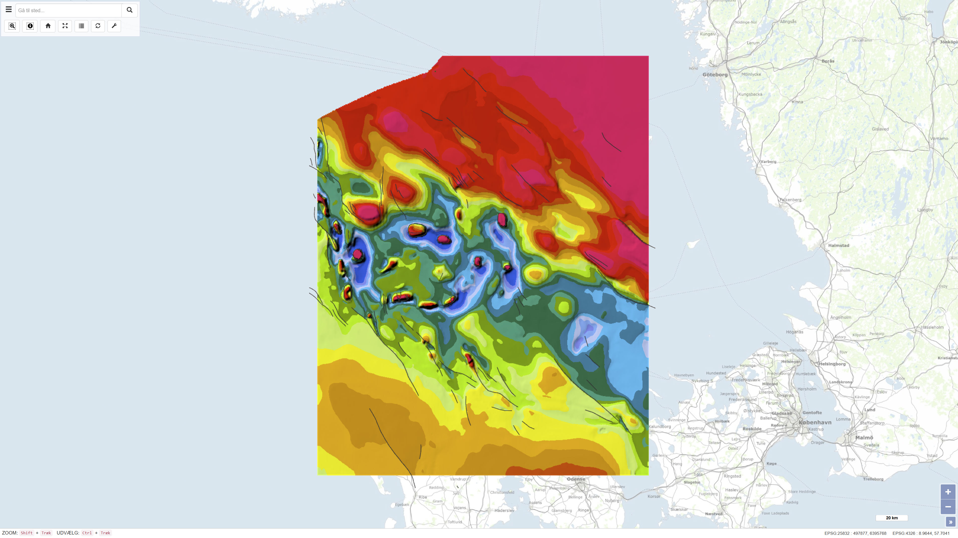
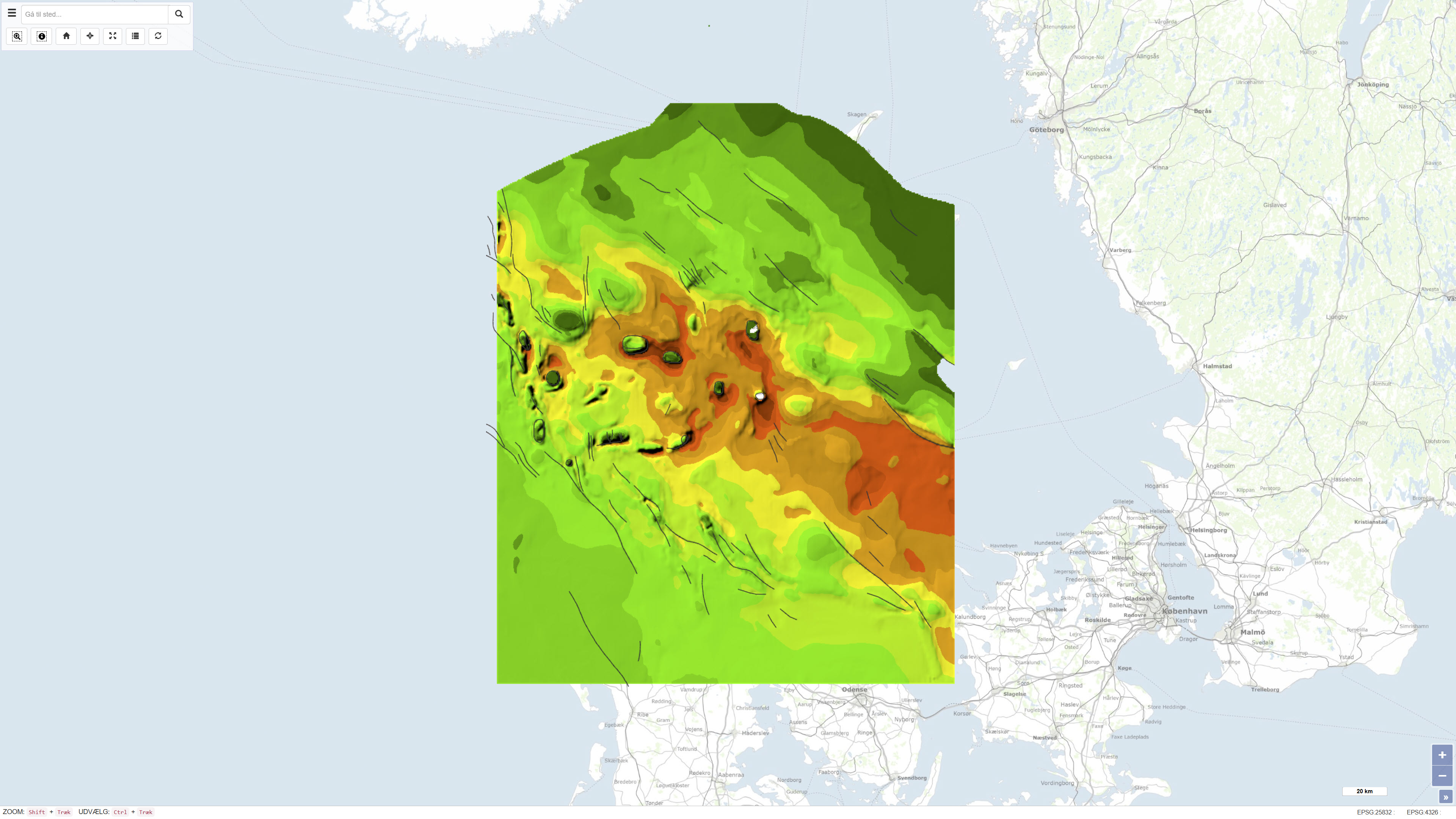
Datasættet omfatter et geologisk kort over Det danske Bassin i målestok 1:400.000, som præsenterer regionale tematiske kort for Basis Kalk og Kalk Gruppen. Kortet er publiceret i 1993 som en del af DGU Kortserie nr. 29 og er udarbejdet som led i regional geologisk kortlægning af bassinet. Kortlægningen er baseret på tolkning af seismiske data suppleret med oplysninger fra dybe boringer på land og offshore. Datasættet består af flere tematiske delkort, der tilsammen viser dybden til Basis Kalk samt den vertikale tykkelse (isochore) af Kalk Gruppen. Kortet dækker Det danske Bassin og tilstødende områder og er udarbejdet til regional strukturel og stratigrafisk fortolkning.
The dataset comprises a geological map of the Danish Basin at a scale of 1:400,000 presenting regional thematic maps of the Base Chalk and the Chalk Group. The map was published in 1993 as part of the DGU Map Series no. 29 and was produced as part of regional geological mapping of the basin. The mapping is based on interpretation of seismic data supplemented by information from deep onshore and offshore boreholes. The dataset consists of several thematic sub-maps that together show the depth to the Base Chalk and the vertical thickness (isochore) of the Chalk Group. The map covers the Danish Basin and adjacent areas and was produced to support regional structural and stratigraphic interpretation.
Simple
Identifikation
- Titel
-
Geologisk kort over Danmark, 1:400.000 - Det danske Bassin: Basis Kalk og Kalkgruppen
Geological Map of Denmark, 1:400.000 - The Danish Basin: Base Chalk and the Chalk Group
Offentliggørelsestidspunkt
-
Dato (Publication)Dato (Publication)
- 1993-01-01
Ansvarlig myndighed og kontaktoplysninger
- Kontakt vedr. service
-
Organisationsnavn E-mail adresse Rolle De Nationale Geologiske Undersøgelser for Danmark og Grønland (GEUS)
The Geological Survey of Denmark and Greenland (GEUS)
Point of contactPoint of contact
- Metadata author
-
Organisationsnavn E-mail adresse Rolle De Nationale Geologiske Undersøgelser for Danmark og Grønland (GEUS)
The Geological Survey of Denmark and Greenland (GEUS)
Point of contactPoint of contact
Geografisk udstrækning
- Koordinatsystem
-
ETRS 89 / UTM 32N (EPSG:25832)
ETRS 89 / UTM 32N (EPSG:25832)
Nøgleord
-
NøgleordNøgleord
-
Datasæt
Dataset
-
NøgleordNøgleord
-
Geologi
Geology
-
NøgleordNøgleord
-
Basis Kalk
Base Chalk
-
NøgleordNøgleord
-
Det Danske Bassin
Danish Basin
-
NøgleordNøgleord
-
Kalk Gruppen
Chalk Group
-
NøgleordNøgleord
-
Danmark
Denmark
-
TypeType
-
ThemeTheme
-
NøgleordNøgleord
-
Tektonik og strukturgeologiTectonics and structural geology
-
NøgleordNøgleord
-
Stratigrafi og korrelationStratigraphy and correlation
-
NøgleordNøgleord
-
Geovidenskab og historiepolitikGeoscience and history policy
-
TypeType
-
ThemeTheme
-
Titel
-
Forskningsemner
-
Dato (Publication)Dato (Publication)
- 2025-11-03
-
NøgleordNøgleord
-
DanmarkDenmark
-
TypeType
-
PlacePlace
-
Titel
-
Geografisk
-
Dato (Publication)Dato (Publication)
- 2025-12-11
Kvalitet
-
Type som metadata beskriverType som metadata beskriver
-
DatasetDataset
-
BeskrivelseBeskrivelse
-
Kortet er publiceret som DGU Kortserie nr. 29 i 1993 og er udarbejdet på baggrund af regional tolkning af seismiske data, suppleret med oplysninger fra dybe boringer på land og offshore. Datagrundlaget omfatter både offentligt tilgængelige og proprietære seismiske data indsamlet over flere årtier forud for udgivelsen. De seismiske og borebaserede tolkninger er anvendt til at fremstille regionale kort for dybden til Basis Kalk samt tykkelseskort for Kalk Gruppen. Datasættet repræsenterer den geologiske fortolkning på udgivelsestidspunktet.
The map was published as DGU Map Series no. 29 in 1993 and was produced based on regional interpretation of seismic data supplemented by information from deep onshore and offshore boreholes. The data basis includes both publicly available and proprietary seismic data acquired over several decades prior to publication. The seismic and borehole-based interpretations were used to compile regional maps of the depth to the Base Chalk as well as thickness maps of the Chalk Group. The dataset represents the geological interpretation available at the time of publication.
)))
