 geodata-info
Israndslinjer i Norden
Ice margin lines in Scandinavia
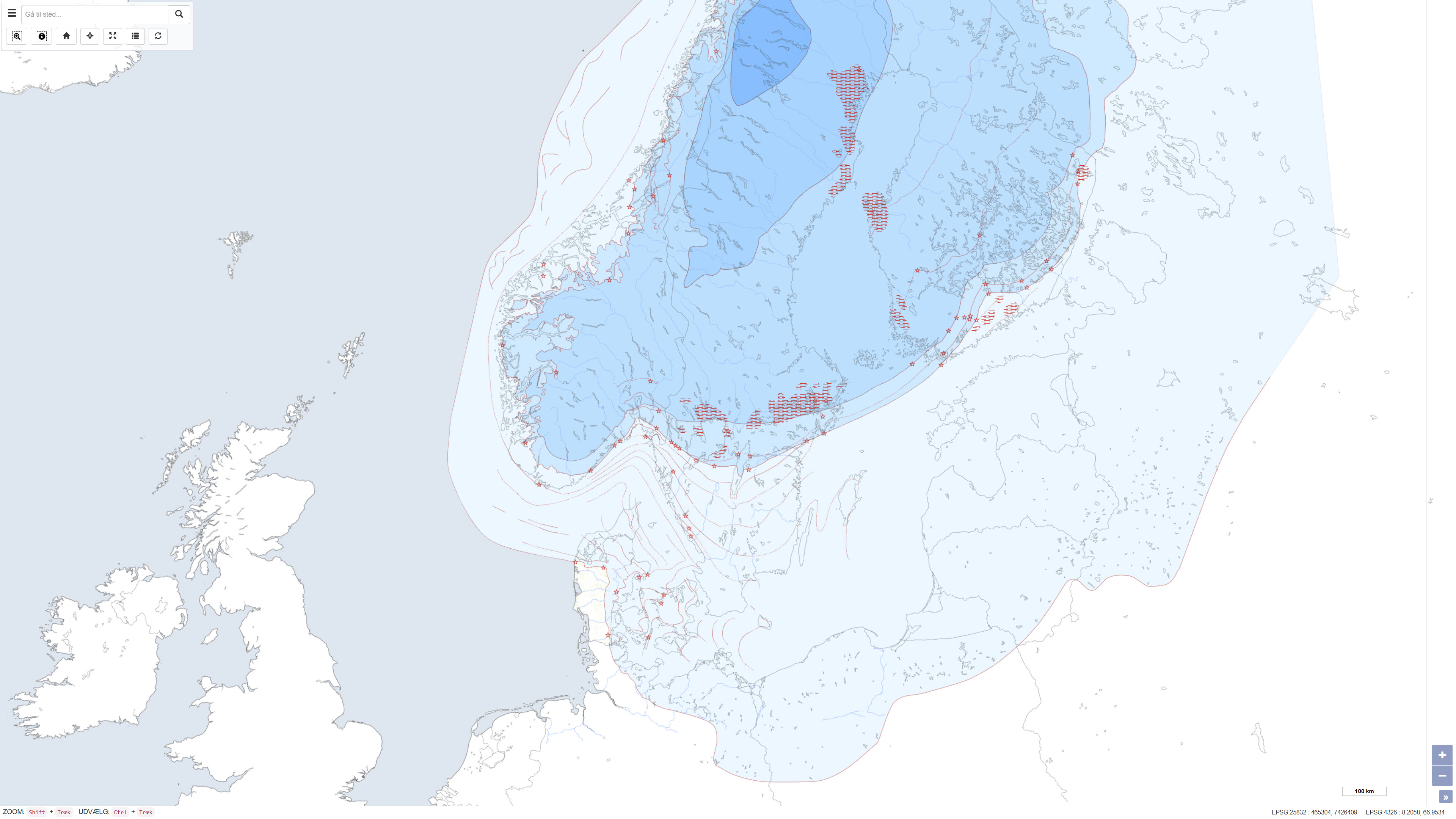
Dette datasæt repræsenterer et kort over israndslinjer og relaterede lokaliteter i Skandinavien, som illustrerer den gradvise afsmeltning af den skandinaviske iskappe under den sidste istid, Weichsel-istiden. Kortet viser iskappens udbredelse i fem overordnede afsmeltningsfaser samt forekomsten af recente iskapper, israndslokaliteter, De Geer-moræner, israndslinjer og hypotetiske israndslinjer. Datasættet er udarbejdet i 1995 i forbindelse med TemaNord og præsenterer et regionalt overblik over isafsmeltningens forløb i Norden. GEUS har ydet en teknisk indsats ved fremstilling af israndskortet.
This dataset represents a map of ice margin lines and related localities in Scandinavia, illustrating the gradual deglaciation of the Scandinavian Ice Sheet during the last glaciation, the Weichsel Ice Age. The map depicts the ice sheet extent in five main deglaciation phases, as well as the occurrence of recent ice caps, ice-margin localities, De Geer moraines, ice margin lines and hypothetical ice margin lines. The dataset was compiled in 1995 in connection with TemaNord and presents a regional overview of the deglaciation history of Scandinavia. GEUS has provided technical input in producing the ice margin map.
Simple
Identifikation
- Titel
-
Israndslinjer i Norden
Ice margin lines in Scandinavia
Offentliggørelsestidspunkt
-
Dato (Publication)Dato (Publication)
- 1998-01-01
Ansvarlig myndighed og kontaktoplysninger
- Kontakt vedr. service
-
Organisationsnavn E-mail adresse Rolle De Nationale Geologiske Undersøgelser for Danmark og Grønland (GEUS)
The Geological Survey of Denmark and Greenland (GEUS)
Point of contactPoint of contact
- Metadata author
-
Organisationsnavn E-mail adresse Rolle De Nationale Geologiske Undersøgelser for Danmark og Grønland (GEUS)
The Geological Survey of Denmark and Greenland (GEUS)
Point of contactPoint of contact
Geografisk udstrækning
- Koordinatsystem
-
ETRS 89 / UTM 32N (EPSG:25832)
ETRS 89 / UTM 32N (EPSG:25832)
Nøgleord
-
NøgleordNøgleord
-
Datasæt
Dataset
-
NøgleordNøgleord
-
Kvartærgeologi
Quaternary geology
-
NøgleordNøgleord
-
Israndslinjer
Ice margin lines
-
NøgleordNøgleord
-
Weichsel
Weichsel
-
NøgleordNøgleord
-
Istid
Ice age
-
NøgleordNøgleord
-
Skandinavien
Scandinavia
-
NøgleordNøgleord
-
ArcGIS
ArcGIS
-
TypeType
-
ThemeTheme
-
NøgleordNøgleord
-
KvartærgeologiQuaternary geology
-
NøgleordNøgleord
-
KryosfærenCryosphere
-
NøgleordNøgleord
-
Geovidenskab og historiepolitikGeoscience and history policy
-
NøgleordNøgleord
-
Atmosfære og klimaAtmosphere and Climate
-
TypeType
-
ThemeTheme
-
Titel
-
Forskningsemner
-
Dato (Publication)Dato (Publication)
- 2025-11-03
-
NøgleordNøgleord
-
NorgeNorway
-
NøgleordNøgleord
-
DanmarkDenmark
-
NøgleordNøgleord
-
SverigeSweden
-
TypeType
-
PlacePlace
-
Titel
-
Geografisk
-
Dato (Publication)Dato (Publication)
- 2025-12-11
Kvalitet
-
Type som metadata beskriverType som metadata beskriver
-
DatasetDataset
-
BeskrivelseBeskrivelse
-
Datasættet er udarbejdet som en del af projektet “Israndslinjer i Norden” og består af digitaliserede og kompilerede data fra de nordiske lande. Kortet er produceret i 1995 og er senere publiceret som en del af rapporten Israndslinier i Norden, udgivet af Nordisk Ministerråd i TemaNord 1998:584. Datasættet repræsenterer en sammenstilling af nationale bidrag og fortolkninger og indeholder udelukkende data for Skandinavien. Data for Island er tilgængelige i en separat datasamling.
The dataset was compiled as part of the project “Ice margin lines in the Nordic countries” and consists of digitised and compiled data contributed by the Nordic countries. The map was produced in 1995 and subsequently published as part of the report Ice margin lines in the Nordic countries, issued by the Nordic Council of Ministers in TemaNord 1998:584. The dataset represents a synthesis of national contributions and interpretations and includes data for Scandinavia only. Data for Iceland are available in a separate dataset.
)))
