 geodata-info
Ice margin lines in Scandinavia
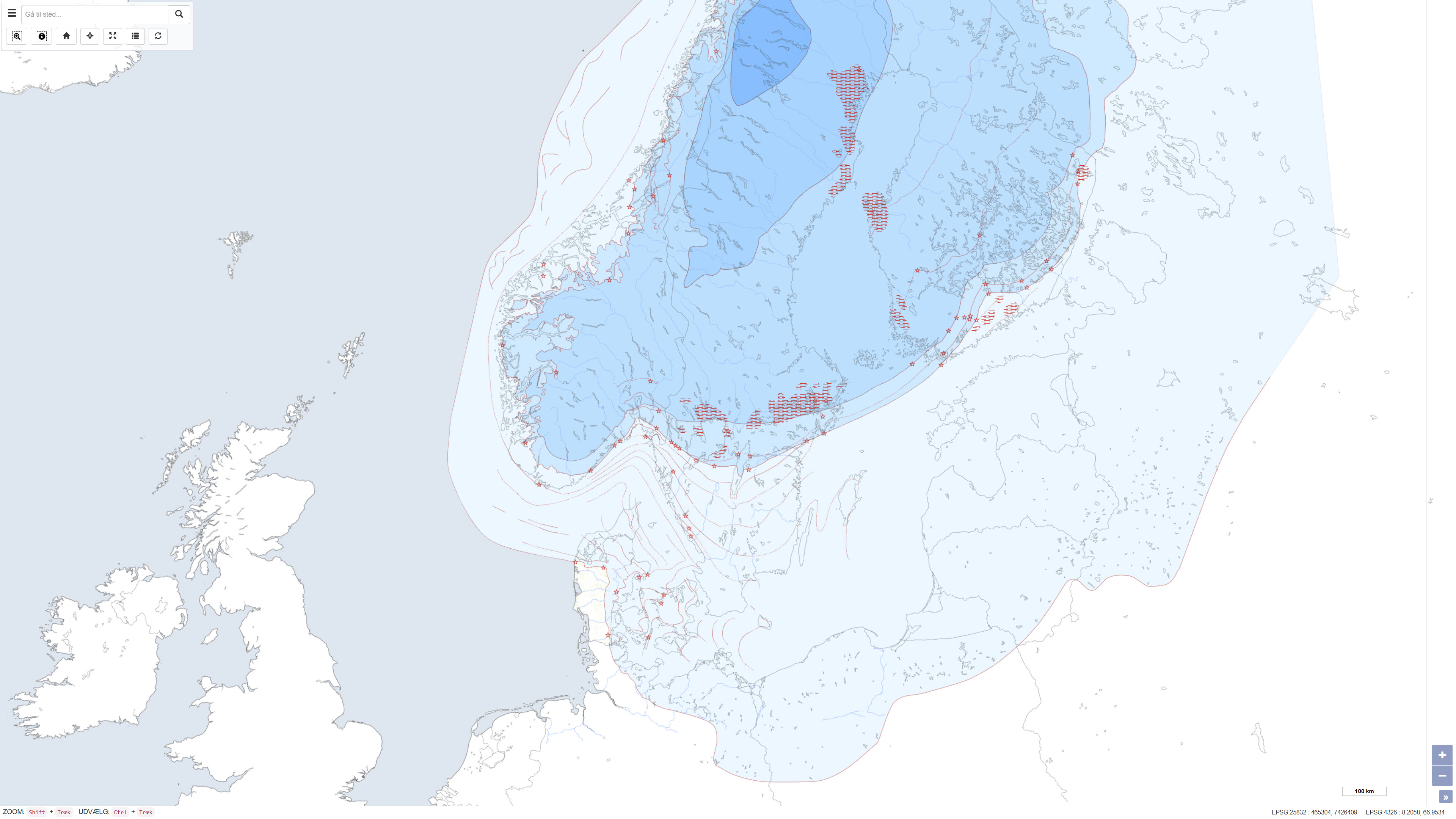
This dataset represents a map of ice margin lines and related localities in Scandinavia, illustrating the gradual deglaciation of the Scandinavian Ice Sheet during the last glaciation, the Weichsel Ice Age. The map depicts the ice sheet extent in five main deglaciation phases, as well as the occurrence of recent ice caps, ice-margin localities, De Geer moraines, ice margin lines and hypothetical ice margin lines. The dataset was compiled in 1995 in connection with TemaNord and presents a regional overview of the deglaciation history of Scandinavia. GEUS has provided technical input in producing the ice margin map.
Simple
Identifikation
- Titel
-
Ice margin lines in Scandinavia
Offentliggørelsestidspunkt
- Dato (Publication)
- 1998-01-01
Ansvarlig myndighed og kontaktoplysninger
- Kontakt vedr. service
-
Organisationsnavn E-mail adresse Rolle The Geological Survey of Denmark and Greenland (GEUS)
Point of contact
- Metadata author
-
Organisationsnavn E-mail adresse Rolle The Geological Survey of Denmark and Greenland (GEUS)
Point of contact
Geografisk udstrækning
- Koordinatsystem
-
ETRS 89 / UTM 32N (EPSG:25832)
Nøgleord
- Nøgleord
-
Dataset
- Nøgleord
-
Quaternary geology
- Nøgleord
-
Ice margin lines
- Nøgleord
-
Weichsel
- Nøgleord
-
Ice age
- Nøgleord
-
Scandinavia
- Nøgleord
-
ArcGIS
- Type
- Theme
- Nøgleord
- Quaternary geology
- Nøgleord
- Cryosphere
- Nøgleord
- Geoscience and history policy
- Nøgleord
- Atmosphere and Climate
- Type
- Theme
- Titel
- Forskningsemner
- Dato (Publication)
- 2025-11-03
- Nøgleord
- Norway
- Nøgleord
- Denmark
- Nøgleord
- Sweden
- Type
- Place
- Titel
- Geografisk
- Dato (Publication)
- 2025-12-11
Kvalitet
- Type som metadata beskriver
- Dataset
- Beskrivelse
-
The dataset was compiled as part of the project “Ice margin lines in the Nordic countries” and consists of digitised and compiled data contributed by the Nordic countries. The map was produced in 1995 and subsequently published as part of the report Ice margin lines in the Nordic countries, issued by the Nordic Council of Ministers in TemaNord 1998:584. The dataset represents a synthesis of national contributions and interpretations and includes data for Scandinavia only. Data for Iceland are available in a separate dataset.
)))
