 geodata-info
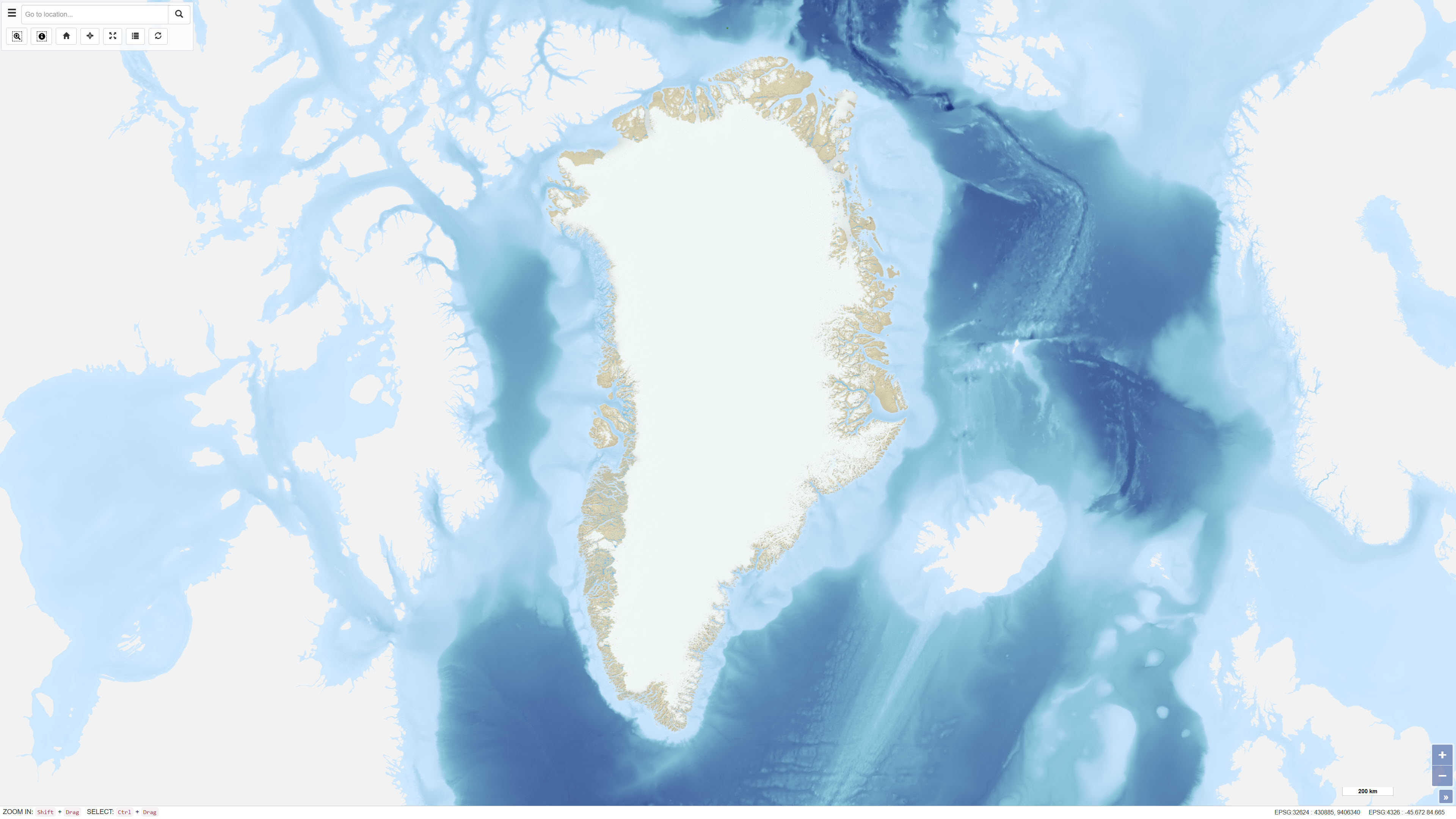
Topografisk kort over Grønland 1:250.000
Topographic map of Greenland 1:250.000
Det topografiske kort over Grønland i målestoksforhold 1:250.000 er baseret på data indsamlet i perioden fra 1930’erne til 1970’erne og 1980’erne. Disse data dannede grundlag for produktionen af en serie topografiske kortblade i 1:250.000, som fortsat udgør det grundlæggende topografiske referencegrundlag for store dele af Grønland.
Kortlægningen af områder før 1970 blev udført på baggrund af flere historiske kortserier, herunder 18 kortblade i målestoksforhold 1:300.000 over Nordgrønland udarbejdet af Lauge Koch i perioden 1932–1940, kortlægning af dele af Nordøstgrønland i 1:250.000 udført af Geodætisk Institut i 1930’erne samt en komplet kortdækning af Grønland i 1:250.000 udarbejdet af American Army Map Service i 1950’erne.
Det digitale topografiske kort for Nord- og Nordøstgrønland er udarbejdet af De Nationale Geologiske Undersøgelser for Danmark og Grønland (GEUS) fra 1977 og frem, baseret på højpræcis digital fotogrammetri af luftfotografier. Kortdataene er primært anvendt som topografisk reference i forbindelse med geologisk kortlægning i målestoksforholdene 1:100.000 og 1:500.000.
The topographic map of Greenland at a scale of 1:250.000 is based on data collected from the 1930s through the 1970s and 1980s. These data formed the basis for the production of a series of 1:250.000 scale topographic map sheets, which continue to serve as the primary topographic reference for large parts of Greenland.
Mapping of areas prior to 1970 was based on several historical map series, including 18 map sheets at a scale of 1:300.000 covering North Greenland produced by Lauge Koch between 1932 and 1940, 1:250,000 scale mapping of parts of Northeast Greenland conducted by the Geodetic Institute in the 1930s, and complete national coverage at 1:250.000 produced by the American Army Map Service in the 1950s.
The digital topographic map of North and Northeast Greenland has been produced by the Geological Survey of Denmark and Greenland (GEUS) since 1977, based on high-precision digital photogrammetry using aerial photographs. The dataset has primarily been used as a topographic reference for geological mapping at scales of 1:100.000 and 1:500.000.
Simple
Identifikation
- Titel
-
Topografisk kort over Grønland 1:250.000
Topographic map of Greenland 1:250.000
Offentliggørelsestidspunkt
-
Dato (Publication)Dato (Publication)
- 2023-03-24
Ansvarlig myndighed og kontaktoplysninger
- Kontakt vedr. service
-
Organisationsnavn E-mail adresse Rolle De Nationale Geologiske Undersøgelser for Danmark og Grønland (GEUS)
The Geological Survey of Denmark and Greenland (GEUS)
Point of contactPoint of contact
- Metadata author
-
Organisationsnavn E-mail adresse Rolle De Nationale Geologiske Undersøgelser for Danmark og Grønland (GEUS)
The Geological Survey of Denmark and Greenland (GEUS)
Point of contactPoint of contact
Geografisk udstrækning
- Koordinatsystem
-
WGS 84 / UTM 24N (EPSG:32624)
WGS 84 / UTM 24N (EPSG:32624)
Nøgleord
-
NøgleordNøgleord
-
Datasæt
Dataset
-
NøgleordNøgleord
-
Topografi
Topography
-
NøgleordNøgleord
-
Greenland
Grønland
-
NøgleordNøgleord
-
Baggrundskort
Basemap
-
NøgleordNøgleord
-
ArcGIS
ArcGIS
-
TypeType
-
ThemeTheme
-
NøgleordNøgleord
-
Geovidenskab og historiepolitikGeoscience and history policy
-
TypeType
-
ThemeTheme
-
Titel
-
Forskningsemner
-
Dato (Publication)Dato (Publication)
- 2025-11-03
-
NøgleordNøgleord
-
GrønlandGreenland
-
TypeType
-
PlacePlace
-
Titel
-
Geografisk
-
Dato (Publication)Dato (Publication)
- 2025-12-11
Kvalitet
-
Type som metadata beskriverType som metadata beskriver
-
DatasetDataset
-
BeskrivelseBeskrivelse
-
De første systematiske topografiske opmålinger af de beboede kystområder i Grønland blev påbegyndt af Geodætisk Institut i 1927 og resulterede i produktionen af en serie topografiske kortblade i målestoksforhold 1:250.000, som fortsat udgør grundlaget for den overordnede topografiske kortlægning af Grønland. Et primært geodætisk net blev etableret med udgangspunkt i en astronomisk station ved Qoornoq. Kortdetaljer blev oprindeligt opmålt ved plane table-opmåling, men i perioden 1932–1938 blev der gennemført omfattende flyfotografering af kystområderne, som dannede grundlag for fotogrammetrisk kortkompilering.
I 1964 var alle isfri områder i Grønland fotograferet, og kortblade var færdiggjort for næsten hele landet. De tidligste kortblade viste terrænet ved hjælp af skravering og højdekurver, mens senere udgaver blev produceret uden terrænskravering, men med farvekodning af lavland og højland. Højdekurver er angivet med 50 meters ækvistance. Kortene blev oprindeligt produceret i Lambert konform konisk projektion eller UTM baseret på den internationale ellipsoide, og datum blev ændret fra Qoornoq Datum til North American Datum 1984. Stednavne er angivet på grønlandsk (inuit) og dansk. Revision af kortbladene har været begrænset til væsentlige rettelser.
Systematic topographic surveying of the inhabited coastal areas of Greenland was initiated by the Geodetic Institute of Denmark in 1927 and resulted in the production of a series of 1:250,000 scale topographic map sheets, which continue to form the basis for the overall topographic mapping of Greenland. A primary geodetic network was established based on an astronomical station at Qoornoq. Initially, map detail was obtained through plane table surveys; however, between 1932 and 1938 extensive aerial photography of the coastal regions was carried out, forming the basis for subsequent photogrammetric compilation.
By 1964, all ice-free areas of Greenland had been photographed, and map sheets were completed for nearly the entire country. Early map sheets depicted relief using hillshading and contour lines, while later editions were produced without relief shading but retained color differentiation between lowland and upland areas. Contours are shown at 50 m intervals. The maps were originally produced using Lambert conformal conic projection or UTM based on the international ellipsoid, and the datum was changed from the Qoornoq Datum to the North American Datum 1984. Place names are provided in Greenlandic (Inuit) and Danish. Revisions of the map sheets have been limited to significant corrections.
%20-%20datas%C3%A6t.jpg)
)))
